You are here: Home > Network List > AV - Alaska Volcano Observatory Stations List
> Station AMKA Regional Station, Amchitka Island, Alaska > Earthquake Result Viewer
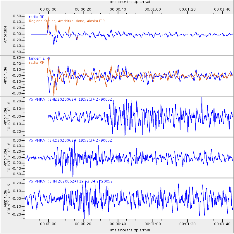
AMKA Regional Station, Amchitka Island, Alaska - Earthquake Result Viewer
*The percent match for this event was below the threshold and hence no stack was calculated.
| Earthquake location: |
Near East Coast Of Honshu, Japan |
| Earthquake latitude/longitude: |
35.5/141.1 |
| Earthquake time(UTC): |
2020/06/24 (176) 19:47:44 GMT |
| Earthquake Depth: |
25 km |
| Earthquake Magnitude: |
5.9 mww |
| Earthquake Catalog/Contributor: |
NEIC PDE/us |
|
| Network: |
AV Alaska Volcano Observatory |
| Station: |
AMKA Regional Station, Amchitka Island, Alaska |
| Lat/Lon: |
51.38 N/179.30 E |
| Elevation: |
116 m |
|
| Distance: |
31.5 deg |
| Az: |
47.761 deg |
| Baz: |
254.672 deg |
| Ray Param: |
$rayparam |
*The percent match for this event was below the threshold and hence was not used in the summary stack. |
|
| Radial Match: |
67.885994 % |
| Radial Bump: |
400 |
| Transverse Match: |
60.05396 % |
| Transverse Bump: |
400 |
| SOD ConfigId: |
21709731 |
| Insert Time: |
2020-07-08 19:52:17.870 +0000 |
| GWidth: |
2.5 |
| Max Bumps: |
400 |
| Tol: |
0.001 |
|
Signal To Noise
| Channel | StoN | STA | LTA |
| AV:AMKA: :BHZ:20200624T19:53:34.279005Z | 3.0805871 | 1.0693419E-7 | 3.4712276E-8 |
| AV:AMKA: :BHN:20200624T19:53:34.279005Z | 0.74168634 | 3.57692E-8 | 4.8226855E-8 |
| AV:AMKA: :BHE:20200624T19:53:34.279005Z | 1.2138547 | 4.630381E-8 | 3.814609E-8 |
| Arrivals |
| Ps | |
| PpPs | |
| PsPs/PpSs | |


