You are here: Home > Network List > UU - University of Utah Regional Network Stations List
> Station FORU South Mineral Mountains, UT, USA > Earthquake Result Viewer
FORU South Mineral Mountains, UT, USA - Earthquake Result Viewer
| Earthquake location: |
Near Coast Of Guatemala |
| Earthquake latitude/longitude: |
13.7/-91.1 |
| Earthquake time(UTC): |
2017/06/22 (173) 12:31:04 GMT |
| Earthquake Depth: |
10 km |
| Earthquake Magnitude: |
6.8 Mi |
| Earthquake Catalog/Contributor: |
NEIC PDE/at |
|
| Network: |
UU University of Utah Regional Network |
| Station: |
FORU South Mineral Mountains, UT, USA |
| Lat/Lon: |
38.46 N/112.86 W |
| Elevation: |
1840 m |
|
| Distance: |
31.3 deg |
| Az: |
325.931 deg |
| Baz: |
136.092 deg |
| Ray Param: |
0.0791046 |
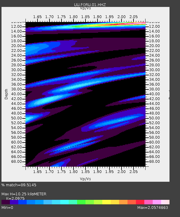
| Estimated Moho Depth: |
10.25 km |
| Estimated Crust Vp/Vs: |
2.10 |
| Assumed Crust Vp: |
6.276 km/s |
| Estimated Crust Vs: |
2.992 km/s |
| Estimated Crust Poisson's Ratio: |
0.35 |
|
| Radial Match: |
89.5145 % |
| Radial Bump: |
400 |
| Transverse Match: |
72.82168 % |
| Transverse Bump: |
400 |
| SOD ConfigId: |
2140511 |
| Insert Time: |
2017-07-06 04:26:19.161 +0000 |
| GWidth: |
2.5 |
| Max Bumps: |
400 |
| Tol: |
0.001 |
|

Signal To Noise
| Channel | StoN | STA | LTA |
| UU:FORU:01:HHZ:20170622T12:36:53.524994Z | 9.050556 | 6.006903E-8 | 6.6370536E-9 |
| UU:FORU:01:HHN:20170622T12:36:53.524994Z | 3.335763 | 4.3292722E-8 | 1.2978357E-8 |
| UU:FORU:01:HHE:20170622T12:36:53.524994Z | 1.9932414 | 2.2128244E-8 | 1.1101638E-8 |
| Arrivals |
| Ps | 1.9 SECOND |
| PpPs | 4.7 SECOND |
| PsPs/PpSs | 6.7 SECOND |


