You are here: Home > Network List > KN - Kyrgyz Seismic Telemetry Network Stations List
> Station USP KN.USP > Earthquake Result Viewer
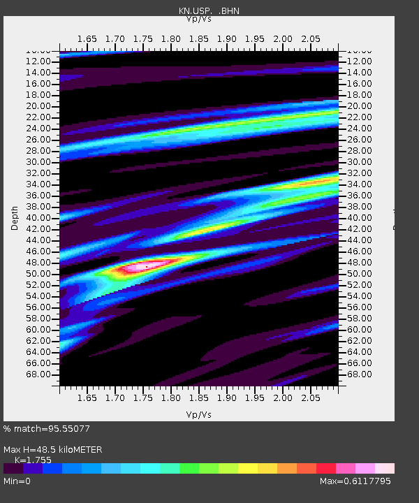
USP KN.USP - Earthquake Result Viewer
| Earthquake location: |
Banda Sea |
| Earthquake latitude/longitude: |
-6.9/129.2 |
| Earthquake time(UTC): |
1995/12/25 (359) 04:43:24 GMT |
| Earthquake Depth: |
150 km |
| Earthquake Magnitude: |
6.2 MB, 7.1 UNKNOWN, 7.1 MW |
| Earthquake Catalog/Contributor: |
WHDF/NEIC |
|
| Network: |
KN Kyrgyz Seismic Telemetry Network |
| Station: |
USP KN.USP |
| Lat/Lon: |
43.27 N/74.50 E |
| Elevation: |
740 m |
|
| Distance: |
70.3 deg |
| Az: |
320.721 deg |
| Baz: |
120.635 deg |
| Ray Param: |
0.054678548 |
| Estimated Moho Depth: |
48.5 km |
| Estimated Crust Vp/Vs: |
1.75 |
| Assumed Crust Vp: |
6.306 km/s |
| Estimated Crust Vs: |
3.593 km/s |
| Estimated Crust Poisson's Ratio: |
0.26 |
|
| Radial Match: |
95.55077 % |
| Radial Bump: |
272 |
| Transverse Match: |
80.40624 % |
| Transverse Bump: |
400 |
| SOD ConfigId: |
6273 |
| Insert Time: |
2010-03-08 22:09:54.430 +0000 |
| GWidth: |
2.5 |
| Max Bumps: |
400 |
| Tol: |
0.001 |
|

Signal To Noise
| Channel | StoN | STA | LTA |
| KN:USP: :BHN:19951225T04:53:51.100012Z | 1.6348677 | 7.694341E-7 | 4.7063997E-7 |
| KN:USP: :BHE:19951225T04:53:51.100012Z | 2.7866 | 6.1630413E-7 | 2.2116707E-7 |
| KN:USP: :BHZ:19951225T04:53:51.100012Z | 11.572272 | 1.9694162E-6 | 1.7018407E-7 |
| Arrivals |
| Ps | 6.0 SECOND |
| PpPs | 20 SECOND |
| PsPs/PpSs | 26 SECOND |


