USP KN.USP - Earthquake Result Viewer
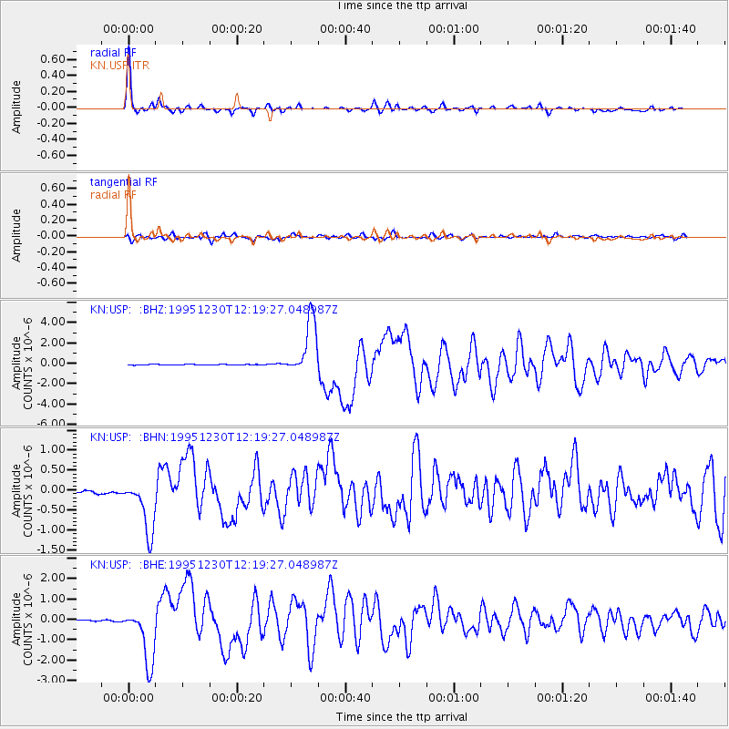
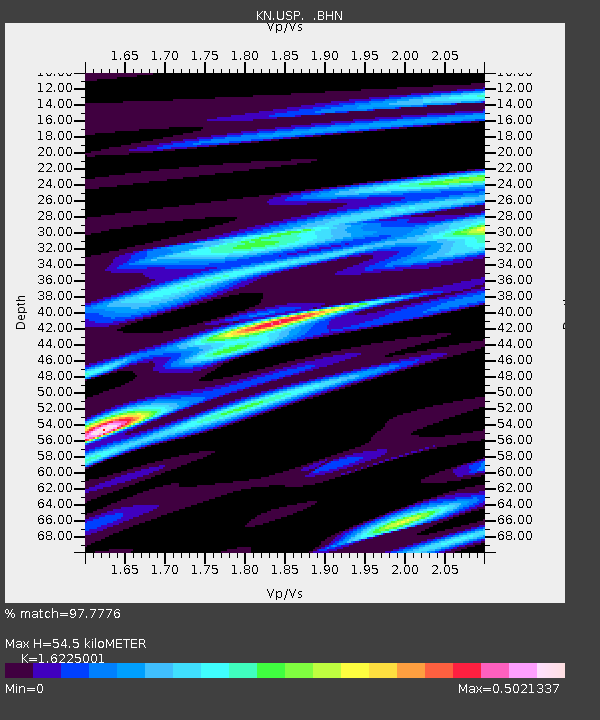
Earthquake location: Off East Coast Of Honshu, Japan
Earthquake latitude/longitude: 40.8/143.4
Earthquake time(UTC): 1995/12/30 (364) 12:11:07 GMT
Earthquake Depth: 33 km
Earthquake Magnitude: 5.7 MB, 6.2 MS, 6.4 UNKNOWN, 6.3 MW
Earthquake Catalog/Contributor: WHDF/NEIC
Network: KN Kyrgyz Seismic Telemetry Network
Station: USP KN.USP
Lat/Lon: 43.27 N/74.50 E
Elevation: 740 m
Distance: 49.9 deg
Az: 297.006 deg
Baz: 67.835 deg
Ray Param: 0.06835153
Estimated Moho Depth: 54.5 km
Estimated Crust Vp/Vs: 1.62
Assumed Crust Vp: 6.306 km/s
Estimated Crust Vs: 3.887 km/s
Estimated Crust Poisson's Ratio: 0.19
Radial Match: 97.7776 %
Radial Bump: 272
Transverse Match: 83.909355 %
Transverse Bump: 400
SOD ConfigId: 6273
Insert Time: 2010-03-08 22:09:56.074 +0000
GWidth: 2.5
Max Bumps: 400
Tol: 0.001

Signal To Noise

ChannelStoNSTALTA
KN:USP: :BHN:19951230T12:19:27.048987Z13.3225897.18211E-75.3909265E-8
KN:USP: :BHE:19951230T12:19:27.048987Z30.8604071.4167547E-64.590849E-8
KN:USP: :BHZ:19951230T12:19:27.048987Z78.1486362.7986173E-63.5811468E-8
Arrivals
Ps5.7 SECOND
PpPs21 SECOND
PsPs/PpSs27 SECOND