You are here: Home > Network List > AV - Alaska Volcano Observatory Stations List
> Station KOKL Mount Kliuchef, Korovin Volcano, Alaska > Earthquake Result Viewer
KOKL Mount Kliuchef, Korovin Volcano, Alaska - Earthquake Result Viewer
| Earthquake location: |
Near East Coast Of Honshu, Japan |
| Earthquake latitude/longitude: |
35.5/141.1 |
| Earthquake time(UTC): |
2020/06/24 (176) 19:47:44 GMT |
| Earthquake Depth: |
25 km |
| Earthquake Magnitude: |
5.9 mww |
| Earthquake Catalog/Contributor: |
NEIC PDE/us |
|
| Network: |
AV Alaska Volcano Observatory |
| Station: |
KOKL Mount Kliuchef, Korovin Volcano, Alaska |
| Lat/Lon: |
52.32 N/174.20 W |
| Elevation: |
758 m |
|
| Distance: |
35.7 deg |
| Az: |
47.711 deg |
| Baz: |
259.727 deg |
| Ray Param: |
0.07705539 |
| Estimated Moho Depth: |
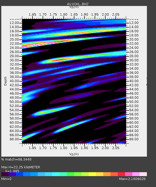
22.25 km |
| Estimated Crust Vp/Vs: |
1.66 |
| Assumed Crust Vp: |
5.88 km/s |
| Estimated Crust Vs: |
3.532 km/s |
| Estimated Crust Poisson's Ratio: |
0.22 |
|
| Radial Match: |
86.3448 % |
| Radial Bump: |
400 |
| Transverse Match: |
66.74545 % |
| Transverse Bump: |
400 |
| SOD ConfigId: |
21709731 |
| Insert Time: |
2020-07-08 19:53:07.647 +0000 |
| GWidth: |
2.5 |
| Max Bumps: |
400 |
| Tol: |
0.001 |
|

Signal To Noise
| Channel | StoN | STA | LTA |
| AV:KOKL: :BHZ:20200624T19:54:10.180006Z | 4.0794716 | 7.5561724E-7 | 1.8522428E-7 |
| AV:KOKL: :BHN:20200624T19:54:10.180006Z | 1.442343 | 4.236189E-7 | 2.937019E-7 |
| AV:KOKL: :BHE:20200624T19:54:10.180006Z | 3.736833 | 1.0213901E-6 | 2.733304E-7 |
| Arrivals |
| Ps | 2.7 SECOND |
| PpPs | 9.4 SECOND |
| PsPs/PpSs | 12 SECOND |


