You are here: Home > Network List > UU - University of Utah Regional Network Stations List
> Station LCMT Little Creek Mountain, UT, USA > Earthquake Result Viewer
LCMT Little Creek Mountain, UT, USA - Earthquake Result Viewer
| Earthquake location: |
Near Coast Of Guatemala |
| Earthquake latitude/longitude: |
13.7/-91.1 |
| Earthquake time(UTC): |
2017/06/22 (173) 12:31:04 GMT |
| Earthquake Depth: |
10 km |
| Earthquake Magnitude: |
6.8 Mi |
| Earthquake Catalog/Contributor: |
NEIC PDE/at |
|
| Network: |
UU University of Utah Regional Network |
| Station: |
LCMT Little Creek Mountain, UT, USA |
| Lat/Lon: |
37.01 N/113.24 W |
| Elevation: |
1411 m |
|
| Distance: |
30.5 deg |
| Az: |
323.523 deg |
| Baz: |
133.792 deg |
| Ray Param: |
0.079316325 |
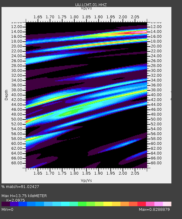
| Estimated Moho Depth: |
13.75 km |
| Estimated Crust Vp/Vs: |
2.10 |
| Assumed Crust Vp: |
6.194 km/s |
| Estimated Crust Vs: |
2.953 km/s |
| Estimated Crust Poisson's Ratio: |
0.35 |
|
| Radial Match: |
91.02427 % |
| Radial Bump: |
254 |
| Transverse Match: |
71.713524 % |
| Transverse Bump: |
400 |
| SOD ConfigId: |
2140511 |
| Insert Time: |
2017-07-06 04:26:24.674 +0000 |
| GWidth: |
2.5 |
| Max Bumps: |
400 |
| Tol: |
0.001 |
|
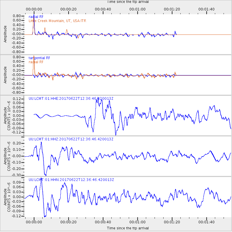
Signal To Noise
| Channel | StoN | STA | LTA |
| UU:LCMT:01:HHZ:20170622T12:36:46.420013Z | 15.251939 | 1.1504203E-7 | 7.542781E-9 |
| UU:LCMT:01:HHN:20170622T12:36:46.420013Z | 13.1065445 | 5.6567007E-8 | 4.315936E-9 |
| UU:LCMT:01:HHE:20170622T12:36:46.420013Z | 9.433419 | 5.853423E-8 | 6.2049854E-9 |
| Arrivals |
| Ps | 2.6 SECOND |
| PpPs | 6.5 SECOND |
| PsPs/PpSs | 9.1 SECOND |


