You are here: Home > Network List > UU - University of Utah Regional Network Stations List
> Station MTPU Mt. Pierson, UT, USA > Earthquake Result Viewer
MTPU Mt. Pierson, UT, USA - Earthquake Result Viewer
| Earthquake location: |
Near Coast Of Guatemala |
| Earthquake latitude/longitude: |
13.7/-91.1 |
| Earthquake time(UTC): |
2017/06/22 (173) 12:31:04 GMT |
| Earthquake Depth: |
10 km |
| Earthquake Magnitude: |
6.8 Mi |
| Earthquake Catalog/Contributor: |
NEIC PDE/at |
|
| Network: |
UU University of Utah Regional Network |
| Station: |
MTPU Mt. Pierson, UT, USA |
| Lat/Lon: |
38.04 N/112.18 W |
| Elevation: |
3112 m |
|
| Distance: |
30.6 deg |
| Az: |
326.122 deg |
| Baz: |
136.673 deg |
| Ray Param: |
0.07928046 |
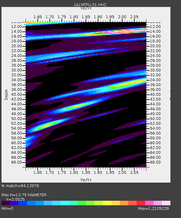
| Estimated Moho Depth: |
13.75 km |
| Estimated Crust Vp/Vs: |
2.00 |
| Assumed Crust Vp: |
6.276 km/s |
| Estimated Crust Vs: |
3.134 km/s |
| Estimated Crust Poisson's Ratio: |
0.33 |
|
| Radial Match: |
94.12878 % |
| Radial Bump: |
338 |
| Transverse Match: |
78.20789 % |
| Transverse Bump: |
400 |
| SOD ConfigId: |
2140511 |
| Insert Time: |
2017-07-06 04:26:29.675 +0000 |
| GWidth: |
2.5 |
| Max Bumps: |
400 |
| Tol: |
0.001 |
|

Signal To Noise
| Channel | StoN | STA | LTA |
| UU:MTPU:01:HHZ:20170622T12:36:47.627991Z | 25.502277 | 1.5675221E-7 | 6.146596E-9 |
| UU:MTPU:01:HHN:20170622T12:36:47.627991Z | 6.251408 | 7.356048E-8 | 1.1767026E-8 |
| UU:MTPU:01:HHE:20170622T12:36:47.627991Z | 5.230448 | 6.289482E-8 | 1.2024748E-8 |
| Arrivals |
| Ps | 2.3 SECOND |
| PpPs | 6.2 SECOND |
| PsPs/PpSs | 8.5 SECOND |


