USP KN.USP - Earthquake Result Viewer
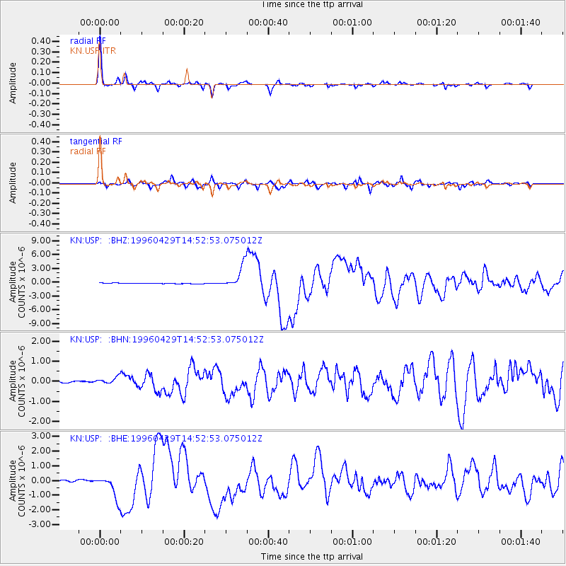
Earthquake location: Solomon Islands
Earthquake latitude/longitude: -6.5/155.0
Earthquake time(UTC): 1996/04/29 (120) 14:40:41 GMT
Earthquake Depth: 44 km
Earthquake Magnitude: 6.3 MB, 7.5 MS, 7.2 UNKNOWN, 6.8 ME
Earthquake Catalog/Contributor: WHDF/NEIC
Network: KN Kyrgyz Seismic Telemetry Network
Station: USP KN.USP
Lat/Lon: 43.27 N/74.50 E
Elevation: 740 m
Distance: 87.5 deg
Az: 313.854 deg
Baz: 101.219 deg
Ray Param: 0.043178875
Estimated Moho Depth: 48.0 km
Estimated Crust Vp/Vs: 1.79
Assumed Crust Vp: 6.306 km/s
Estimated Crust Vs: 3.518 km/s
Estimated Crust Poisson's Ratio: 0.27
Radial Match: 97.93968 %
Radial Bump: 219
Transverse Match: 89.751976 %
Transverse Bump: 400
SOD ConfigId: 6273
Insert Time: 2010-03-08 22:10:24.888 +0000
GWidth: 2.5
Max Bumps: 400
Tol: 0.001

Signal To Noise

ChannelStoNSTALTA
KN:USP: :BHN:19960429T14:52:53.075012Z4.8425232.2226591E-74.589878E-8
KN:USP: :BHE:19960429T14:52:53.075012Z20.4152648.4153663E-74.1220954E-8
KN:USP: :BHZ:19960429T14:52:53.075012Z40.04592.6414934E-66.596165E-8
Arrivals
Ps6.2 SECOND
PpPs21 SECOND
PsPs/PpSs27 SECOND