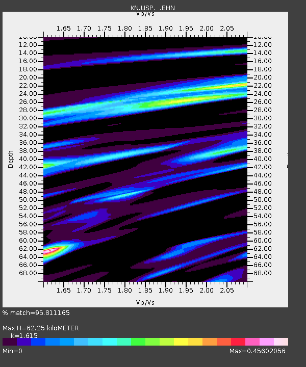
USP KN.USP - Earthquake Result Viewer
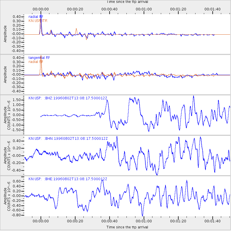
Earthquake location: Solomon Islands
Earthquake latitude/longitude: -10.8/161.4
Earthquake time(UTC): 1996/08/02 (215) 12:55:29 GMT
Earthquake Depth: 33 km
Earthquake Magnitude: 6.2 MB, 7.1 MS, 6.9 UNKNOWN, 6.9 MW
Earthquake Catalog/Contributor: WHDF/NEIC
Network: KN Kyrgyz Seismic Telemetry Network
Station: USP KN.USP
Lat/Lon: 43.27 N/74.50 E
Elevation: 740 m
Distance: 95.1 deg
Az: 312.92 deg
Baz: 99.907 deg
Ray Param: 0.040863093
Estimated Moho Depth: 62.25 km
Estimated Crust Vp/Vs: 1.62
Assumed Crust Vp: 6.306 km/s
Estimated Crust Vs: 3.905 km/s
Estimated Crust Poisson's Ratio: 0.19
Radial Match: 95.811165 %
Radial Bump: 349
Transverse Match: 61.612316 %
Transverse Bump: 400
SOD ConfigId: 6273
Insert Time: 2010-03-08 22:10:47.343 +0000
GWidth: 2.5
Max Bumps: 400
Tol: 0.001

Signal To Noise

ChannelStoNSTALTA
KN:USP: :BHN:19960802T13:08:17.500012Z1.88884191.2461733E-76.597552E-8
KN:USP: :BHE:19960802T13:08:17.500012Z1.41370267.607615E-85.38134E-8
KN:USP: :BHZ:19960802T13:08:17.500012Z3.06372021.6898986E-75.5158385E-8
Arrivals
Ps6.2 SECOND
PpPs25 SECOND
PsPs/PpSs31 SECOND