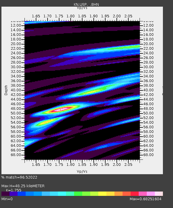
USP KN.USP - Earthquake Result Viewer
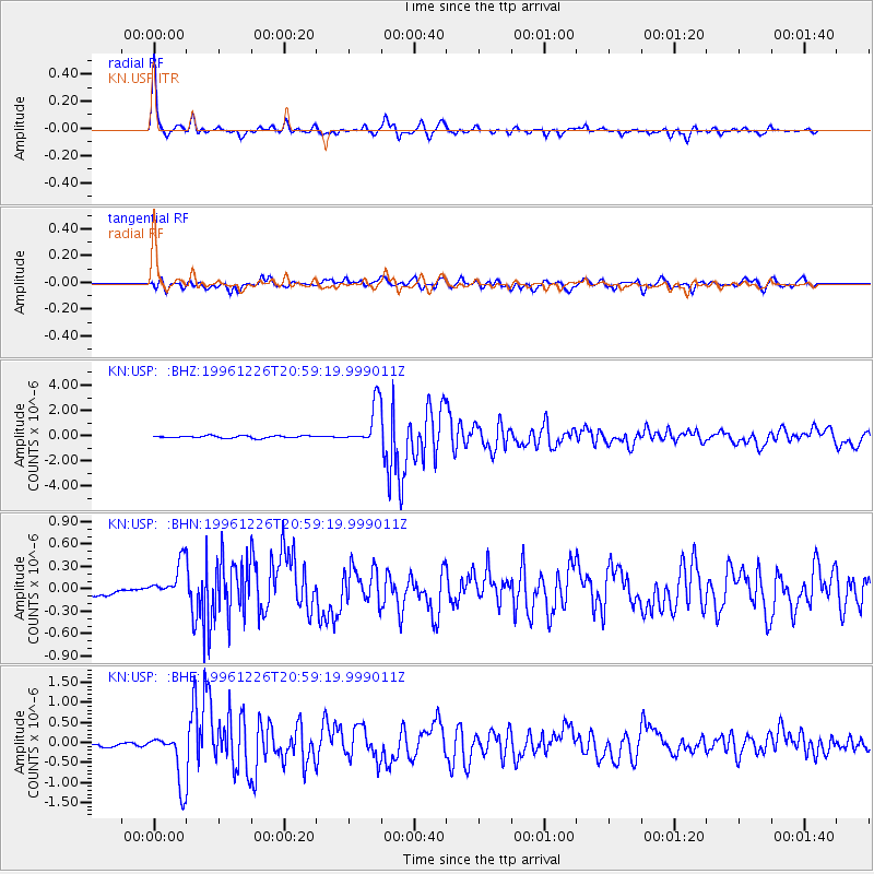
Earthquake location: Irian Jaya, Indonesia
Earthquake latitude/longitude: -2.2/138.9
Earthquake time(UTC): 1996/12/26 (361) 20:48:23 GMT
Earthquake Depth: 33 km
Earthquake Magnitude: 6.0 MB, 6.1 MS, 6.3 UNKNOWN, 6.1 MW
Earthquake Catalog/Contributor: WHDF/NEIC
Network: KN Kyrgyz Seismic Telemetry Network
Station: USP KN.USP
Lat/Lon: 43.27 N/74.50 E
Elevation: 740 m
Distance: 73.2 deg
Az: 316.51 deg
Baz: 109.7 deg
Ray Param: 0.053091325
Estimated Moho Depth: 48.25 km
Estimated Crust Vp/Vs: 1.75
Assumed Crust Vp: 6.306 km/s
Estimated Crust Vs: 3.593 km/s
Estimated Crust Poisson's Ratio: 0.26
Radial Match: 96.52022 %
Radial Bump: 310
Transverse Match: 82.183945 %
Transverse Bump: 400
SOD ConfigId: 6273
Insert Time: 2010-03-08 22:10:56.366 +0000
GWidth: 2.5
Max Bumps: 400
Tol: 0.001

Signal To Noise

ChannelStoNSTALTA
KN:USP: :BHN:19961226T20:59:19.999011Z8.614282.791481E-73.240528E-8
KN:USP: :BHE:19961226T20:59:19.999011Z16.1709736.351611E-73.9277854E-8
KN:USP: :BHZ:19961226T20:59:19.999011Z19.2256431.6687703E-68.67992E-8
Arrivals
Ps6.0 SECOND
PpPs20 SECOND
PsPs/PpSs26 SECOND