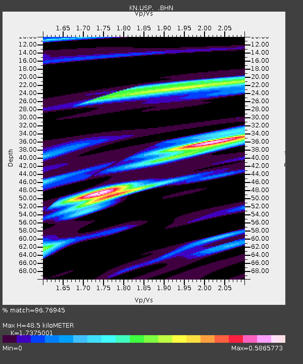
USP KN.USP - Earthquake Result Viewer
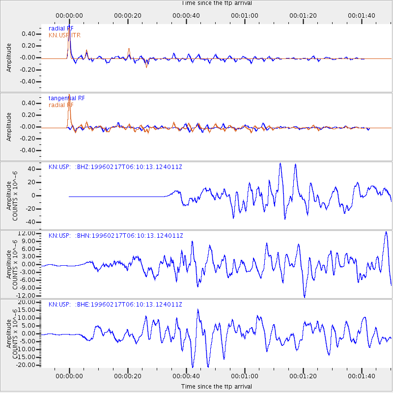
Earthquake location: Irian Jaya Region, Indonesia
Earthquake latitude/longitude: -0.9/137.0
Earthquake time(UTC): 1996/02/17 (048) 05:59:29 GMT
Earthquake Depth: 33 km
Earthquake Magnitude: 6.5 MB, 8.1 MS, 7.9 UNKNOWN
Earthquake Catalog/Contributor: WHDF/NEIC
Network: KN Kyrgyz Seismic Telemetry Network
Station: USP KN.USP
Lat/Lon: 43.27 N/74.50 E
Elevation: 740 m
Distance: 71.0 deg
Az: 316.728 deg
Baz: 110.237 deg
Ray Param: 0.05456548
Estimated Moho Depth: 48.5 km
Estimated Crust Vp/Vs: 1.74
Assumed Crust Vp: 6.306 km/s
Estimated Crust Vs: 3.629 km/s
Estimated Crust Poisson's Ratio: 0.25
Radial Match: 96.76945 %
Radial Bump: 307
Transverse Match: 82.41499 %
Transverse Bump: 400
SOD ConfigId: 6273
Insert Time: 2010-03-08 22:11:07.480 +0000
GWidth: 2.5
Max Bumps: 400
Tol: 0.001

Signal To Noise

ChannelStoNSTALTA
KN:USP: :BHN:19960217T06:10:13.124011Z0.71230974.288327E-76.020312E-7
KN:USP: :BHE:19960217T06:10:13.124011Z2.47701884.948127E-71.9976139E-7
KN:USP: :BHZ:19960217T06:10:13.124011Z11.3556911.435079E-61.2637531E-7
Arrivals
Ps5.9 SECOND
PpPs20 SECOND
PsPs/PpSs26 SECOND