You are here: Home > Network List > UU - University of Utah Regional Network Stations List
> Station FOR2 Blundell East, UT, USA > Earthquake Result Viewer
FOR2 Blundell East, UT, USA - Earthquake Result Viewer
| Earthquake location: |
Near Coast Of Guatemala |
| Earthquake latitude/longitude: |
13.7/-91.1 |
| Earthquake time(UTC): |
2017/06/22 (173) 12:31:04 GMT |
| Earthquake Depth: |
10 km |
| Earthquake Magnitude: |
6.8 Mi |
| Earthquake Catalog/Contributor: |
NEIC PDE/at |
|
| Network: |
UU University of Utah Regional Network |
| Station: |
FOR2 Blundell East, UT, USA |
| Lat/Lon: |
38.49 N/112.87 W |
| Elevation: |
1760 m |
|
| Distance: |
31.3 deg |
| Az: |
325.967 deg |
| Baz: |
136.116 deg |
| Ray Param: |
0.0790962 |
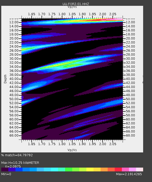
| Estimated Moho Depth: |
10.25 km |
| Estimated Crust Vp/Vs: |
2.10 |
| Assumed Crust Vp: |
6.276 km/s |
| Estimated Crust Vs: |
2.992 km/s |
| Estimated Crust Poisson's Ratio: |
0.35 |
|
| Radial Match: |
84.79792 % |
| Radial Bump: |
400 |
| Transverse Match: |
56.70371 % |
| Transverse Bump: |
400 |
| SOD ConfigId: |
2140511 |
| Insert Time: |
2017-07-06 04:26:56.816 +0000 |
| GWidth: |
2.5 |
| Max Bumps: |
400 |
| Tol: |
0.001 |
|

Signal To Noise
| Channel | StoN | STA | LTA |
| UU:FOR2:01:HHZ:20170622T12:36:53.809998Z | 19.926544 | 8.897669E-8 | 4.465235E-9 |
| UU:FOR2:01:HHN:20170622T12:36:53.809998Z | 1.178085 | 3.571803E-8 | 3.0318724E-8 |
| UU:FOR2:01:HHE:20170622T12:36:53.809998Z | 6.2849336 | 4.80687E-8 | 7.648243E-9 |
| Arrivals |
| Ps | 1.9 SECOND |
| PpPs | 4.7 SECOND |
| PsPs/PpSs | 6.7 SECOND |


