You are here: Home > Network List > TA - USArray Transportable Network (new EarthScope stations) Stations List
> Station A22K Sinclair Lake, AK, USA > Earthquake Result Viewer
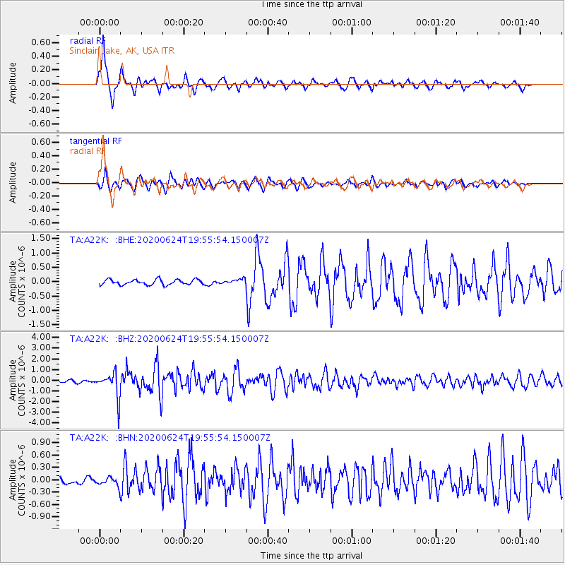
A22K Sinclair Lake, AK, USA - Earthquake Result Viewer
| Earthquake location: |
Near East Coast Of Honshu, Japan |
| Earthquake latitude/longitude: |
35.5/141.1 |
| Earthquake time(UTC): |
2020/06/24 (176) 19:47:44 GMT |
| Earthquake Depth: |
25 km |
| Earthquake Magnitude: |
5.9 mww |
| Earthquake Catalog/Contributor: |
NEIC PDE/us |
|
| Network: |
TA USArray Transportable Network (new EarthScope stations) |
| Station: |
A22K Sinclair Lake, AK, USA |
| Lat/Lon: |
71.00 N/154.97 W |
| Elevation: |
6.0 m |
|
| Distance: |
48.4 deg |
| Az: |
23.137 deg |
| Baz: |
258.405 deg |
| Ray Param: |
0.069317326 |
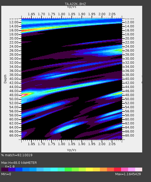
| Estimated Moho Depth: |
48.0 km |
| Estimated Crust Vp/Vs: |
1.60 |
| Assumed Crust Vp: |
5.782 km/s |
| Estimated Crust Vs: |
3.614 km/s |
| Estimated Crust Poisson's Ratio: |
0.18 |
|
| Radial Match: |
92.10019 % |
| Radial Bump: |
400 |
| Transverse Match: |
77.89737 % |
| Transverse Bump: |
400 |
| SOD ConfigId: |
21709731 |
| Insert Time: |
2020-07-08 20:10:28.897 +0000 |
| GWidth: |
2.5 |
| Max Bumps: |
400 |
| Tol: |
0.001 |
|
Signal To Noise
| Channel | StoN | STA | LTA |
| TA:A22K: :BHZ:20200624T19:55:54.150007Z | 12.91416 | 1.2370455E-6 | 9.578985E-8 |
| TA:A22K: :BHN:20200624T19:55:54.150007Z | 1.2349557 | 1.0272467E-7 | 8.318086E-8 |
| TA:A22K: :BHE:20200624T19:55:54.150007Z | 0.94720066 | 8.703358E-8 | 9.188505E-8 |
| Arrivals |
| Ps | 5.3 SECOND |
| PpPs | 20 SECOND |
| PsPs/PpSs | 26 SECOND |


