You are here: Home > Network List > TA - USArray Transportable Network (new EarthScope stations) Stations List
> Station C21K Knifeblade Ridge, AK, USA > Earthquake Result Viewer
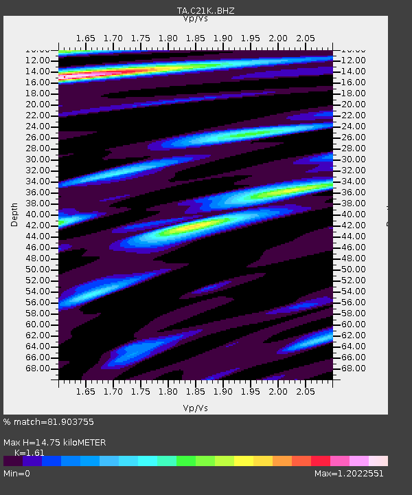
C21K Knifeblade Ridge, AK, USA - Earthquake Result Viewer
| Earthquake location: |
Near East Coast Of Honshu, Japan |
| Earthquake latitude/longitude: |
35.5/141.1 |
| Earthquake time(UTC): |
2020/06/24 (176) 19:47:44 GMT |
| Earthquake Depth: |
25 km |
| Earthquake Magnitude: |
5.9 mww |
| Earthquake Catalog/Contributor: |
NEIC PDE/us |
|
| Network: |
TA USArray Transportable Network (new EarthScope stations) |
| Station: |
C21K Knifeblade Ridge, AK, USA |
| Lat/Lon: |
69.16 N/154.78 W |
| Elevation: |
409 m |
|
| Distance: |
48.2 deg |
| Az: |
25.596 deg |
| Baz: |
260.221 deg |
| Ray Param: |
0.06949893 |
| Estimated Moho Depth: |
14.75 km |
| Estimated Crust Vp/Vs: |
1.61 |
| Assumed Crust Vp: |
6.221 km/s |
| Estimated Crust Vs: |
3.864 km/s |
| Estimated Crust Poisson's Ratio: |
0.19 |
|
| Radial Match: |
81.903755 % |
| Radial Bump: |
400 |
| Transverse Match: |
78.064156 % |
| Transverse Bump: |
400 |
| SOD ConfigId: |
21709731 |
| Insert Time: |
2020-07-08 20:10:42.504 +0000 |
| GWidth: |
2.5 |
| Max Bumps: |
400 |
| Tol: |
0.001 |
|

Signal To Noise
| Channel | StoN | STA | LTA |
| TA:C21K: :BHZ:20200624T19:55:51.974989Z | 4.039276 | 4.4813694E-7 | 1.1094486E-7 |
| TA:C21K: :BHN:20200624T19:55:51.974989Z | 0.96621174 | 6.76546E-8 | 7.002047E-8 |
| TA:C21K: :BHE:20200624T19:55:51.974989Z | 2.3842893 | 1.1064071E-7 | 4.640406E-8 |
| Arrivals |
| Ps | 1.5 SECOND |
| PpPs | 5.8 SECOND |
| PsPs/PpSs | 7.4 SECOND |


