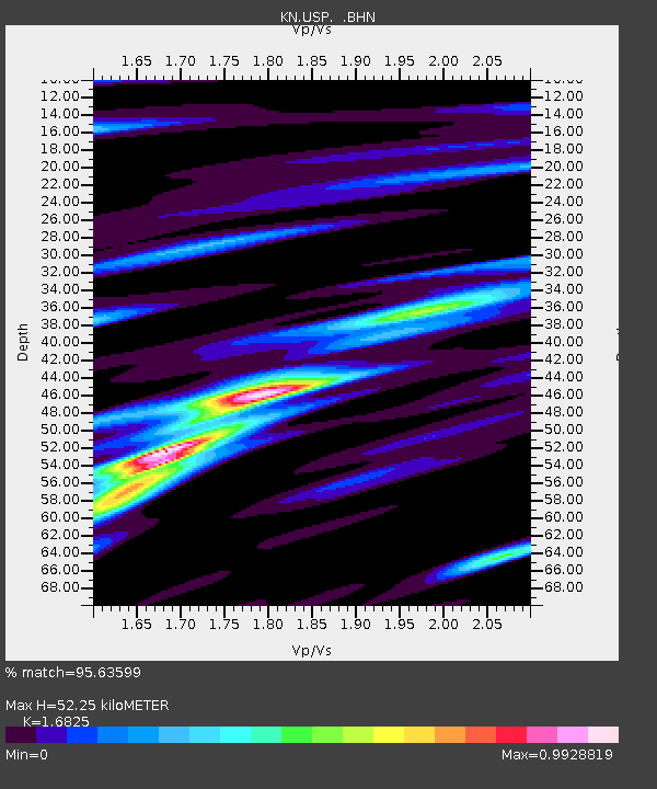
USP KN.USP - Earthquake Result Viewer
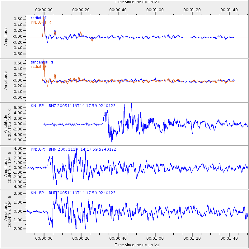
Earthquake location: Northern Sumatra, Indonesia
Earthquake latitude/longitude: 2.2/96.8
Earthquake time(UTC): 2005/11/19 (323) 14:10:13 GMT
Earthquake Depth: 21 km
Earthquake Magnitude: 6.0 MB, 6.1 MS, 6.5 MW, 6.5 MW
Earthquake Catalog/Contributor: WHDF/NEIC
Network: KN Kyrgyz Seismic Telemetry Network
Station: USP KN.USP
Lat/Lon: 43.27 N/74.50 E
Elevation: 740 m
Distance: 45.5 deg
Az: 337.142 deg
Baz: 147.899 deg
Ray Param: 0.0712138
Estimated Moho Depth: 52.25 km
Estimated Crust Vp/Vs: 1.68
Assumed Crust Vp: 6.306 km/s
Estimated Crust Vs: 3.748 km/s
Estimated Crust Poisson's Ratio: 0.23
Radial Match: 95.63599 %
Radial Bump: 359
Transverse Match: 83.56167 %
Transverse Bump: 400
SOD ConfigId: 2448
Insert Time: 2010-03-08 22:12:29.918 +0000
GWidth: 2.5
Max Bumps: 400
Tol: 0.001

Signal To Noise

ChannelStoNSTALTA
KN:USP: :BHN:20051119T14:17:59.924012Z10.8407641.2595251E-61.1618416E-7
KN:USP: :BHE:20051119T14:17:59.924012Z3.53737.130123E-72.0156963E-7
KN:USP: :BHZ:20051119T14:17:59.924012Z14.1613052.4742055E-61.7471592E-7
Arrivals
Ps6.0 SECOND
PpPs21 SECOND
PsPs/PpSs27 SECOND