You are here: Home > Network List > TA - USArray Transportable Network (new EarthScope stations) Stations List
> Station D19K Kuna River, AK, USA > Earthquake Result Viewer
D19K Kuna River, AK, USA - Earthquake Result Viewer
| Earthquake location: |
Near East Coast Of Honshu, Japan |
| Earthquake latitude/longitude: |
35.5/141.1 |
| Earthquake time(UTC): |
2020/06/24 (176) 19:47:44 GMT |
| Earthquake Depth: |
25 km |
| Earthquake Magnitude: |
5.9 mww |
| Earthquake Catalog/Contributor: |
NEIC PDE/us |
|
| Network: |
TA USArray Transportable Network (new EarthScope stations) |
| Station: |
D19K Kuna River, AK, USA |
| Lat/Lon: |
68.49 N/158.12 W |
| Elevation: |
671 m |
|
| Distance: |
46.9 deg |
| Az: |
26.163 deg |
| Baz: |
257.5 deg |
| Ray Param: |
0.070343085 |
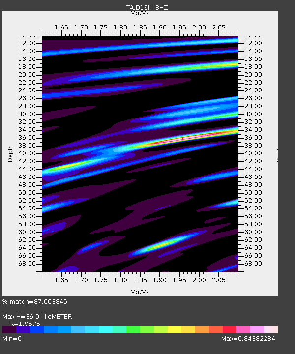
| Estimated Moho Depth: |
36.0 km |
| Estimated Crust Vp/Vs: |
1.96 |
| Assumed Crust Vp: |
6.221 km/s |
| Estimated Crust Vs: |
3.178 km/s |
| Estimated Crust Poisson's Ratio: |
0.32 |
|
| Radial Match: |
87.003845 % |
| Radial Bump: |
400 |
| Transverse Match: |
86.320175 % |
| Transverse Bump: |
400 |
| SOD ConfigId: |
21709731 |
| Insert Time: |
2020-07-08 20:10:50.929 +0000 |
| GWidth: |
2.5 |
| Max Bumps: |
400 |
| Tol: |
0.001 |
|

Signal To Noise
| Channel | StoN | STA | LTA |
| TA:D19K: :BHZ:20200624T19:55:41.775007Z | 10.595303 | 6.3358584E-7 | 5.979875E-8 |
| TA:D19K: :BHN:20200624T19:55:41.775007Z | 1.082029 | 5.904318E-8 | 5.4567092E-8 |
| TA:D19K: :BHE:20200624T19:55:41.775007Z | 4.4406953 | 1.9654696E-7 | 4.4260403E-8 |
| Arrivals |
| Ps | 5.8 SECOND |
| PpPs | 16 SECOND |
| PsPs/PpSs | 22 SECOND |


