You are here: Home > Network List > TA - USArray Transportable Network (new EarthScope stations) Stations List
> Station D23K Nanushuk River, AK USA > Earthquake Result Viewer
D23K Nanushuk River, AK USA - Earthquake Result Viewer
| Earthquake location: |
Near East Coast Of Honshu, Japan |
| Earthquake latitude/longitude: |
35.5/141.1 |
| Earthquake time(UTC): |
2020/06/24 (176) 19:47:44 GMT |
| Earthquake Depth: |
25 km |
| Earthquake Magnitude: |
5.9 mww |
| Earthquake Catalog/Contributor: |
NEIC PDE/us |
|
| Network: |
TA USArray Transportable Network (new EarthScope stations) |
| Station: |
D23K Nanushuk River, AK USA |
| Lat/Lon: |
68.97 N/150.68 W |
| Elevation: |
406 m |
|
| Distance: |
49.6 deg |
| Az: |
26.11 deg |
| Baz: |
264.387 deg |
| Ray Param: |
0.06857063 |
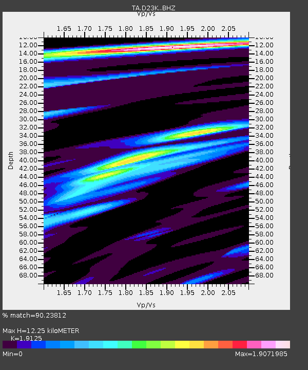
| Estimated Moho Depth: |
12.25 km |
| Estimated Crust Vp/Vs: |
1.91 |
| Assumed Crust Vp: |
6.221 km/s |
| Estimated Crust Vs: |
3.253 km/s |
| Estimated Crust Poisson's Ratio: |
0.31 |
|
| Radial Match: |
90.23812 % |
| Radial Bump: |
400 |
| Transverse Match: |
75.65633 % |
| Transverse Bump: |
400 |
| SOD ConfigId: |
21709731 |
| Insert Time: |
2020-07-08 20:10:54.069 +0000 |
| GWidth: |
2.5 |
| Max Bumps: |
400 |
| Tol: |
0.001 |
|

Signal To Noise
| Channel | StoN | STA | LTA |
| TA:D23K: :BHZ:20200624T19:56:02.974989Z | 4.320198 | 4.474922E-7 | 1.0358141E-7 |
| TA:D23K: :BHN:20200624T19:56:02.974989Z | 1.3627932 | 6.6177186E-8 | 4.855996E-8 |
| TA:D23K: :BHE:20200624T19:56:02.974989Z | 3.317083 | 1.7759372E-7 | 5.3539125E-8 |
| Arrivals |
| Ps | 1.9 SECOND |
| PpPs | 5.5 SECOND |
| PsPs/PpSs | 7.3 SECOND |


