You are here: Home > Network List > TA - USArray Transportable Network (new EarthScope stations) Stations List
> Station F24K Squaw Lake, AK, USA > Earthquake Result Viewer
F24K Squaw Lake, AK, USA - Earthquake Result Viewer
| Earthquake location: |
Near East Coast Of Honshu, Japan |
| Earthquake latitude/longitude: |
35.5/141.1 |
| Earthquake time(UTC): |
2020/06/24 (176) 19:47:44 GMT |
| Earthquake Depth: |
25 km |
| Earthquake Magnitude: |
5.9 mww |
| Earthquake Catalog/Contributor: |
NEIC PDE/us |
|
| Network: |
TA USArray Transportable Network (new EarthScope stations) |
| Station: |
F24K Squaw Lake, AK, USA |
| Lat/Lon: |
67.52 N/147.89 W |
| Elevation: |
736 m |
|
| Distance: |
50.6 deg |
| Az: |
28.089 deg |
| Baz: |
268.25 deg |
| Ray Param: |
0.067940176 |
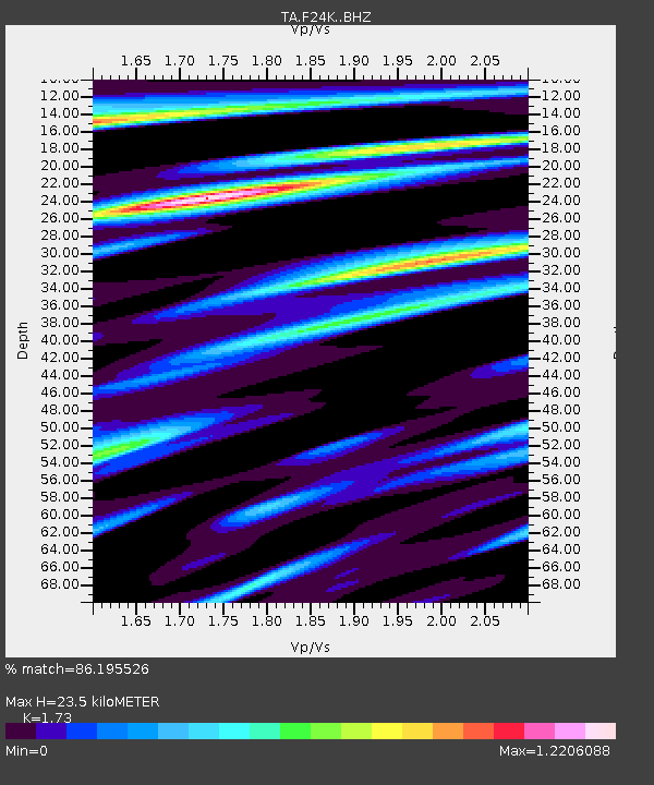
| Estimated Moho Depth: |
23.5 km |
| Estimated Crust Vp/Vs: |
1.73 |
| Assumed Crust Vp: |
6.522 km/s |
| Estimated Crust Vs: |
3.77 km/s |
| Estimated Crust Poisson's Ratio: |
0.25 |
|
| Radial Match: |
86.195526 % |
| Radial Bump: |
400 |
| Transverse Match: |
64.976685 % |
| Transverse Bump: |
400 |
| SOD ConfigId: |
21709731 |
| Insert Time: |
2020-07-08 20:11:28.187 +0000 |
| GWidth: |
2.5 |
| Max Bumps: |
400 |
| Tol: |
0.001 |
|
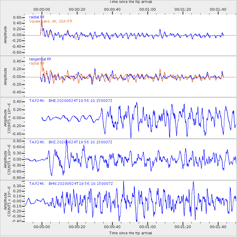
Signal To Noise
| Channel | StoN | STA | LTA |
| TA:F24K: :BHZ:20200624T19:56:10.150007Z | 2.7839751 | 1.7425114E-7 | 6.2590765E-8 |
| TA:F24K: :BHN:20200624T19:56:10.150007Z | 1.0055192 | 4.265232E-8 | 4.2418208E-8 |
| TA:F24K: :BHE:20200624T19:56:10.150007Z | 2.4651937 | 9.678647E-8 | 3.9261206E-8 |
| Arrivals |
| Ps | 2.8 SECOND |
| PpPs | 9.3 SECOND |
| PsPs/PpSs | 12 SECOND |


