You are here: Home > Network List > TA - USArray Transportable Network (new EarthScope stations) Stations List
> Station G30M t˙h Zraii Njik, YT, CAN > Earthquake Result Viewer
G30M t˙h Zraii Njik, YT, CAN - Earthquake Result Viewer
| Earthquake location: |
Near East Coast Of Honshu, Japan |
| Earthquake latitude/longitude: |
35.5/141.1 |
| Earthquake time(UTC): |
2020/06/24 (176) 19:47:44 GMT |
| Earthquake Depth: |
25 km |
| Earthquake Magnitude: |
5.9 mww |
| Earthquake Catalog/Contributor: |
NEIC PDE/us |
|
| Network: |
TA USArray Transportable Network (new EarthScope stations) |
| Station: |
G30M t˙h Zraii Njik, YT, CAN |
| Lat/Lon: |
66.98 N/136.22 W |
| Elevation: |
739 m |
|
| Distance: |
55.1 deg |
| Az: |
28.393 deg |
| Baz: |
279.187 deg |
| Ray Param: |
0.064976044 |
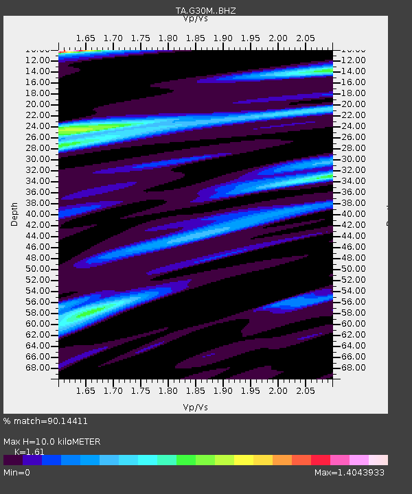
| Estimated Moho Depth: |
10.0 km |
| Estimated Crust Vp/Vs: |
1.61 |
| Assumed Crust Vp: |
6.522 km/s |
| Estimated Crust Vs: |
4.051 km/s |
| Estimated Crust Poisson's Ratio: |
0.19 |
|
| Radial Match: |
90.14411 % |
| Radial Bump: |
400 |
| Transverse Match: |
86.88483 % |
| Transverse Bump: |
400 |
| SOD ConfigId: |
21709731 |
| Insert Time: |
2020-07-08 20:11:52.437 +0000 |
| GWidth: |
2.5 |
| Max Bumps: |
400 |
| Tol: |
0.001 |
|

Signal To Noise
| Channel | StoN | STA | LTA |
| TA:G30M: :BHZ:20200624T19:56:43.725019Z | 13.161978 | 8.8366517E-7 | 6.713772E-8 |
| TA:G30M: :BHN:20200624T19:56:43.725019Z | 2.8759005 | 1.4259503E-7 | 4.958274E-8 |
| TA:G30M: :BHE:20200624T19:56:43.725019Z | 5.677058 | 3.0513306E-7 | 5.3748447E-8 |
| Arrivals |
| Ps | 1.0 SECOND |
| PpPs | 3.8 SECOND |
| PsPs/PpSs | 4.8 SECOND |


