You are here: Home > Network List > TA - USArray Transportable Network (new EarthScope stations) Stations List
> Station I17K Unalakleet, AK, USA > Earthquake Result Viewer
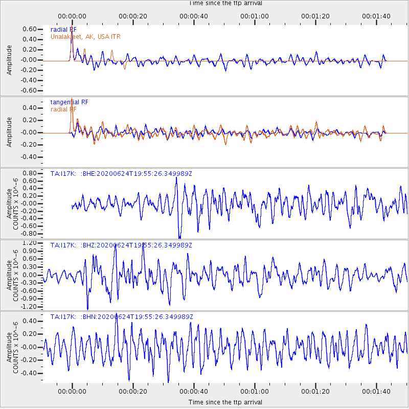
I17K Unalakleet, AK, USA - Earthquake Result Viewer
*The percent match for this event was below the threshold and hence no stack was calculated.
| Earthquake location: |
Near East Coast Of Honshu, Japan |
| Earthquake latitude/longitude: |
35.5/141.1 |
| Earthquake time(UTC): |
2020/06/24 (176) 19:47:44 GMT |
| Earthquake Depth: |
25 km |
| Earthquake Magnitude: |
5.9 mww |
| Earthquake Catalog/Contributor: |
NEIC PDE/us |
|
| Network: |
TA USArray Transportable Network (new EarthScope stations) |
| Station: |
I17K Unalakleet, AK, USA |
| Lat/Lon: |
63.89 N/160.70 W |
| Elevation: |
105 m |
|
| Distance: |
44.9 deg |
| Az: |
32.187 deg |
| Baz: |
259.337 deg |
| Ray Param: |
$rayparam |
*The percent match for this event was below the threshold and hence was not used in the summary stack. |
|
| Radial Match: |
65.534164 % |
| Radial Bump: |
400 |
| Transverse Match: |
53.79317 % |
| Transverse Bump: |
400 |
| SOD ConfigId: |
21709731 |
| Insert Time: |
2020-07-08 20:12:05.937 +0000 |
| GWidth: |
2.5 |
| Max Bumps: |
400 |
| Tol: |
0.001 |
|
Signal To Noise
| Channel | StoN | STA | LTA |
| TA:I17K: :BHZ:20200624T19:55:26.349989Z | 1.5509179 | 2.2846777E-7 | 1.4731134E-7 |
| TA:I17K: :BHN:20200624T19:55:26.349989Z | 1.4793578 | 1.7643153E-7 | 1.1926224E-7 |
| TA:I17K: :BHE:20200624T19:55:26.349989Z | 1.9977928 | 2.6583422E-7 | 1.3306396E-7 |
| Arrivals |
| Ps | |
| PpPs | |
| PsPs/PpSs | |


