You are here: Home > Network List > TA - USArray Transportable Network (new EarthScope stations) Stations List
> Station J30M Hart River, Yukon, CAN > Earthquake Result Viewer
J30M Hart River, Yukon, CAN - Earthquake Result Viewer
| Earthquake location: |
Near East Coast Of Honshu, Japan |
| Earthquake latitude/longitude: |
35.5/141.1 |
| Earthquake time(UTC): |
2020/06/24 (176) 19:47:44 GMT |
| Earthquake Depth: |
25 km |
| Earthquake Magnitude: |
5.9 mww |
| Earthquake Catalog/Contributor: |
NEIC PDE/us |
|
| Network: |
TA USArray Transportable Network (new EarthScope stations) |
| Station: |
J30M Hart River, Yukon, CAN |
| Lat/Lon: |
64.58 N/136.33 W |
| Elevation: |
1419 m |
|
| Distance: |
55.5 deg |
| Az: |
31.298 deg |
| Baz: |
280.741 deg |
| Ray Param: |
0.064723134 |
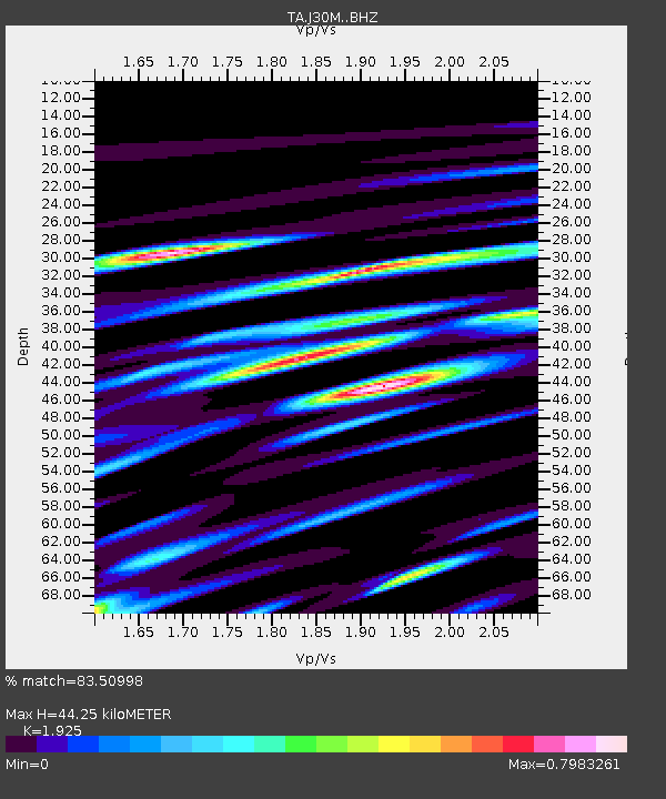
| Estimated Moho Depth: |
44.25 km |
| Estimated Crust Vp/Vs: |
1.92 |
| Assumed Crust Vp: |
6.566 km/s |
| Estimated Crust Vs: |
3.411 km/s |
| Estimated Crust Poisson's Ratio: |
0.32 |
|
| Radial Match: |
83.50998 % |
| Radial Bump: |
400 |
| Transverse Match: |
75.783066 % |
| Transverse Bump: |
400 |
| SOD ConfigId: |
21709731 |
| Insert Time: |
2020-07-08 20:12:14.866 +0000 |
| GWidth: |
2.5 |
| Max Bumps: |
400 |
| Tol: |
0.001 |
|

Signal To Noise
| Channel | StoN | STA | LTA |
| TA:J30M: :BHZ:20200624T19:56:46.400007Z | 2.9993012 | 1.7371822E-7 | 5.791956E-8 |
| TA:J30M: :BHN:20200624T19:56:46.400007Z | 1.1849649 | 4.7306145E-8 | 3.9921982E-8 |
| TA:J30M: :BHE:20200624T19:56:46.400007Z | 3.0932462 | 1.09443846E-7 | 3.538155E-8 |
| Arrivals |
| Ps | 6.6 SECOND |
| PpPs | 19 SECOND |
| PsPs/PpSs | 25 SECOND |


