You are here: Home > Network List > TA - USArray Transportable Network (new EarthScope stations) Stations List
> Station L15K Ungalak Mountain, AK, USA > Earthquake Result Viewer
L15K Ungalak Mountain, AK, USA - Earthquake Result Viewer
| Earthquake location: |
Near East Coast Of Honshu, Japan |
| Earthquake latitude/longitude: |
35.5/141.1 |
| Earthquake time(UTC): |
2020/06/24 (176) 19:47:44 GMT |
| Earthquake Depth: |
25 km |
| Earthquake Magnitude: |
5.9 mww |
| Earthquake Catalog/Contributor: |
NEIC PDE/us |
|
| Network: |
TA USArray Transportable Network (new EarthScope stations) |
| Station: |
L15K Ungalak Mountain, AK, USA |
| Lat/Lon: |
61.68 N/161.49 W |
| Elevation: |
219 m |
|
| Distance: |
44.2 deg |
| Az: |
35.212 deg |
| Baz: |
260.79 deg |
| Ray Param: |
0.07206672 |
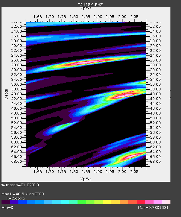
| Estimated Moho Depth: |
40.5 km |
| Estimated Crust Vp/Vs: |
2.01 |
| Assumed Crust Vp: |
6.182 km/s |
| Estimated Crust Vs: |
3.08 km/s |
| Estimated Crust Poisson's Ratio: |
0.33 |
|
| Radial Match: |
81.07013 % |
| Radial Bump: |
400 |
| Transverse Match: |
63.386387 % |
| Transverse Bump: |
400 |
| SOD ConfigId: |
21709731 |
| Insert Time: |
2020-07-08 20:12:21.129 +0000 |
| GWidth: |
2.5 |
| Max Bumps: |
400 |
| Tol: |
0.001 |
|

Signal To Noise
| Channel | StoN | STA | LTA |
| TA:L15K: :BHZ:20200624T19:55:20.449995Z | 1.4592913 | 1.6817273E-7 | 1.1524274E-7 |
| TA:L15K: :BHN:20200624T19:55:20.449995Z | 0.94207513 | 7.461686E-8 | 7.920478E-8 |
| TA:L15K: :BHE:20200624T19:55:20.449995Z | 1.8978597 | 1.344992E-7 | 7.0868886E-8 |
| Arrivals |
| Ps | 7.0 SECOND |
| PpPs | 19 SECOND |
| PsPs/PpSs | 26 SECOND |


