You are here: Home > Network List > KN - Kyrgyz Seismic Telemetry Network Stations List
> Station USP KN.USP > Earthquake Result Viewer
USP KN.USP - Earthquake Result Viewer

| Earthquake location: |
Mindanao, Philippines |
| Earthquake latitude/longitude: |
5.3/123.3 |
| Earthquake time(UTC): |
2005/02/05 (036) 12:23:18 GMT |
| Earthquake Depth: |
525 km |
| Earthquake Magnitude: |
6.4 MB, 7.1 MW, 7.1 MW |
| Earthquake Catalog/Contributor: |
WHDF/NEIC |
|
| Network: |
KN Kyrgyz Seismic Telemetry Network |
| Station: |
USP KN.USP |
| Lat/Lon: |
43.27 N/74.50 E |
| Elevation: |
740 m |
|
| Distance: |
57.2 deg |
| Az: |
319.152 deg |
| Baz: |
116.922 deg |
| Ray Param: |
0.06151439 |
| Estimated Moho Depth: |
47.5 km |
| Estimated Crust Vp/Vs: |
1.76 |
| Assumed Crust Vp: |
6.306 km/s |
| Estimated Crust Vs: |
3.578 km/s |
| Estimated Crust Poisson's Ratio: |
0.26 |
|
| Radial Match: |
95.55465 % |
| Radial Bump: |
269 |
| Transverse Match: |
86.99463 % |
| Transverse Bump: |
400 |
| SOD ConfigId: |
5233 |
| Insert Time: |
2010-03-08 22:12:55.202 +0000 |
| GWidth: |
2.5 |
| Max Bumps: |
400 |
| Tol: |
0.001 |
|
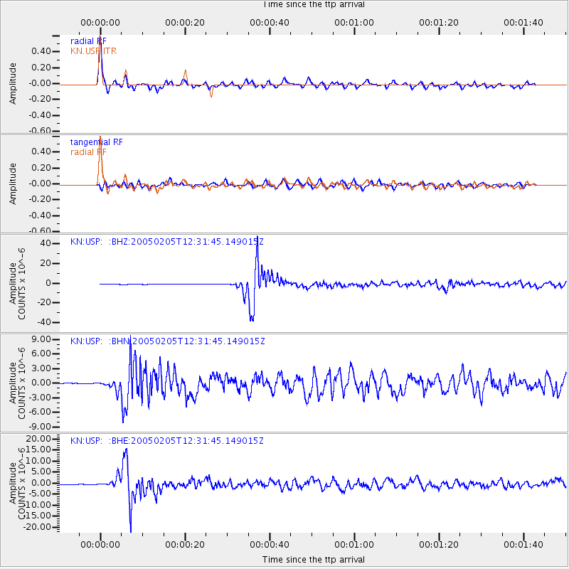
Signal To Noise
| Channel | StoN | STA | LTA |
| KN:USP: :BHN:20050205T12:31:45.149015Z | 12.0454445 | 9.37179E-7 | 7.78036E-8 |
| KN:USP: :BHE:20050205T12:31:45.149015Z | 20.056187 | 2.2018532E-6 | 1.09784246E-7 |
| KN:USP: :BHZ:20050205T12:31:45.149015Z | 44.36961 | 5.471997E-6 | 1.233276E-7 |
| Arrivals |
| Ps | 6.0 SECOND |
| PpPs | 20 SECOND |
| PsPs/PpSs | 26 SECOND |


