You are here: Home > Network List > TA - USArray Transportable Network (new EarthScope stations) Stations List
> Station M31M Drury Creek, Yukon, CA > Earthquake Result Viewer
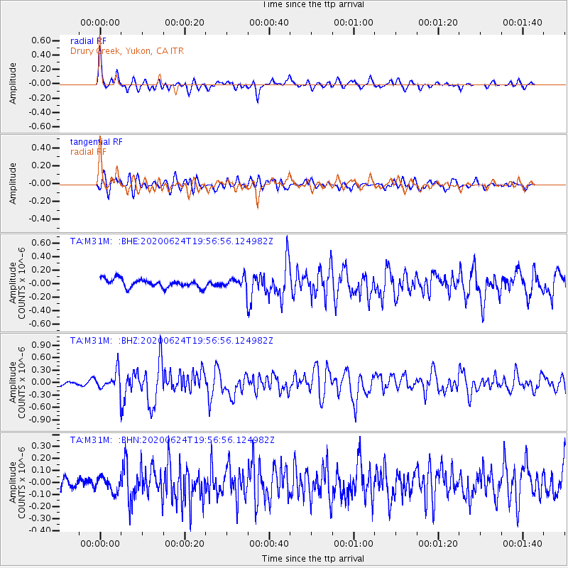
M31M Drury Creek, Yukon, CA - Earthquake Result Viewer
*The percent match for this event was below the threshold and hence no stack was calculated.
| Earthquake location: |
Near East Coast Of Honshu, Japan |
| Earthquake latitude/longitude: |
35.5/141.1 |
| Earthquake time(UTC): |
2020/06/24 (176) 19:47:44 GMT |
| Earthquake Depth: |
25 km |
| Earthquake Magnitude: |
5.9 mww |
| Earthquake Catalog/Contributor: |
NEIC PDE/us |
|
| Network: |
TA USArray Transportable Network (new EarthScope stations) |
| Station: |
M31M Drury Creek, Yukon, CA |
| Lat/Lon: |
62.20 N/134.39 W |
| Elevation: |
639 m |
|
| Distance: |
56.8 deg |
| Az: |
33.875 deg |
| Baz: |
283.909 deg |
| Ray Param: |
$rayparam |
*The percent match for this event was below the threshold and hence was not used in the summary stack. |
|
| Radial Match: |
73.547615 % |
| Radial Bump: |
393 |
| Transverse Match: |
73.046974 % |
| Transverse Bump: |
400 |
| SOD ConfigId: |
21709731 |
| Insert Time: |
2020-07-08 20:12:37.604 +0000 |
| GWidth: |
2.5 |
| Max Bumps: |
400 |
| Tol: |
0.001 |
|
Signal To Noise
| Channel | StoN | STA | LTA |
| TA:M31M: :BHZ:20200624T19:56:56.124982Z | 3.6834185 | 2.2982303E-7 | 6.239395E-8 |
| TA:M31M: :BHN:20200624T19:56:56.124982Z | 1.3685427 | 6.0197436E-8 | 4.3986525E-8 |
| TA:M31M: :BHE:20200624T19:56:56.124982Z | 1.4543426 | 8.995377E-8 | 6.185184E-8 |
| Arrivals |
| Ps | |
| PpPs | |
| PsPs/PpSs | |


