You are here: Home > Network List > US - United States National Seismic Network Stations List
> Station MSO Missoula, Montana, USA > Earthquake Result Viewer
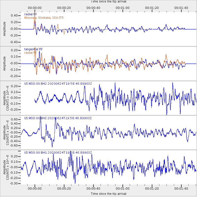
MSO Missoula, Montana, USA - Earthquake Result Viewer
*The percent match for this event was below the threshold and hence no stack was calculated.
| Earthquake location: |
Near East Coast Of Honshu, Japan |
| Earthquake latitude/longitude: |
35.5/141.1 |
| Earthquake time(UTC): |
2020/06/24 (176) 19:47:44 GMT |
| Earthquake Depth: |
25 km |
| Earthquake Magnitude: |
5.9 mww |
| Earthquake Catalog/Contributor: |
NEIC PDE/us |
|
| Network: |
US United States National Seismic Network |
| Station: |
MSO Missoula, Montana, USA |
| Lat/Lon: |
46.83 N/113.94 W |
| Elevation: |
1264 m |
|
| Distance: |
74.0 deg |
| Az: |
43.643 deg |
| Baz: |
304.851 deg |
| Ray Param: |
$rayparam |
*The percent match for this event was below the threshold and hence was not used in the summary stack. |
|
| Radial Match: |
67.71967 % |
| Radial Bump: |
400 |
| Transverse Match: |
76.77581 % |
| Transverse Bump: |
400 |
| SOD ConfigId: |
21709731 |
| Insert Time: |
2020-07-08 20:15:31.170 +0000 |
| GWidth: |
2.5 |
| Max Bumps: |
400 |
| Tol: |
0.001 |
|
Signal To Noise
| Channel | StoN | STA | LTA |
| US:MSO:00:BHZ:20200624T19:58:46.89903Z | 3.5654771 | 2.6099303E-7 | 7.320003E-8 |
| US:MSO:00:BH1:20200624T19:58:46.89903Z | 1.2471398 | 7.6923925E-8 | 6.1680275E-8 |
| US:MSO:00:BH2:20200624T19:58:46.89903Z | 1.9443308 | 9.5798036E-8 | 4.927044E-8 |
| Arrivals |
| Ps | |
| PpPs | |
| PsPs/PpSs | |


