You are here: Home > Network List > UW - Pacific Northwest Regional Seismic Network Stations List
> Station UMAT Pilot Rock, OR, USA > Earthquake Result Viewer
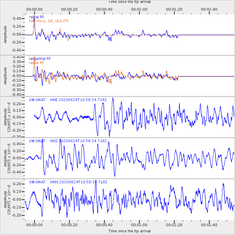
UMAT Pilot Rock, OR, USA - Earthquake Result Viewer
*The percent match for this event was below the threshold and hence no stack was calculated.
| Earthquake location: |
Near East Coast Of Honshu, Japan |
| Earthquake latitude/longitude: |
35.5/141.1 |
| Earthquake time(UTC): |
2020/06/24 (176) 19:47:44 GMT |
| Earthquake Depth: |
25 km |
| Earthquake Magnitude: |
5.9 mww |
| Earthquake Catalog/Contributor: |
NEIC PDE/us |
|
| Network: |
UW Pacific Northwest Regional Seismic Network |
| Station: |
UMAT Pilot Rock, OR, USA |
| Lat/Lon: |
45.29 N/118.96 W |
| Elevation: |
1318 m |
|
| Distance: |
71.9 deg |
| Az: |
47.003 deg |
| Baz: |
302.231 deg |
| Ray Param: |
$rayparam |
*The percent match for this event was below the threshold and hence was not used in the summary stack. |
|
| Radial Match: |
74.24458 % |
| Radial Bump: |
400 |
| Transverse Match: |
67.95315 % |
| Transverse Bump: |
400 |
| SOD ConfigId: |
21709731 |
| Insert Time: |
2020-07-08 20:17:15.705 +0000 |
| GWidth: |
2.5 |
| Max Bumps: |
400 |
| Tol: |
0.001 |
|
Signal To Noise
| Channel | StoN | STA | LTA |
| UW:UMAT: :HHZ:20200624T19:58:34.718Z | 2.4621677 | 1.8381238E-7 | 7.465469E-8 |
| UW:UMAT: :HHN:20200624T19:58:34.718Z | 2.2967384 | 8.887811E-8 | 3.8697532E-8 |
| UW:UMAT: :HHE:20200624T19:58:34.718Z | 1.2062323 | 6.239101E-8 | 5.1723877E-8 |
| Arrivals |
| Ps | |
| PpPs | |
| PsPs/PpSs | |


