You are here: Home > Network List > KN - Kyrgyz Seismic Telemetry Network Stations List
> Station USP KN.USP > Earthquake Result Viewer
USP KN.USP - Earthquake Result Viewer
| Earthquake location: |
Mariana Islands |
| Earthquake latitude/longitude: |
18.9/145.4 |
| Earthquake time(UTC): |
2007/10/31 (304) 03:30:17 GMT |
| Earthquake Depth: |
223 km |
| Earthquake Magnitude: |
6.2 MB, 7.2 MW, 7.2 MW |
| Earthquake Catalog/Contributor: |
WHDF/NEIC |
|
| Network: |
KN Kyrgyz Seismic Telemetry Network |
| Station: |
USP KN.USP |
| Lat/Lon: |
43.27 N/74.50 E |
| Elevation: |
740 m |
|
| Distance: |
63.5 deg |
| Az: |
309.532 deg |
| Baz: |
88.516 deg |
| Ray Param: |
0.058861133 |
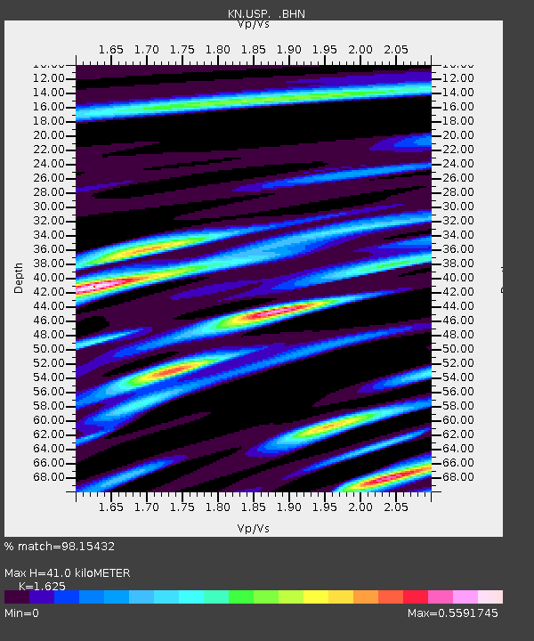
| Estimated Moho Depth: |
41.0 km |
| Estimated Crust Vp/Vs: |
1.62 |
| Assumed Crust Vp: |
6.306 km/s |
| Estimated Crust Vs: |
3.881 km/s |
| Estimated Crust Poisson's Ratio: |
0.20 |
|
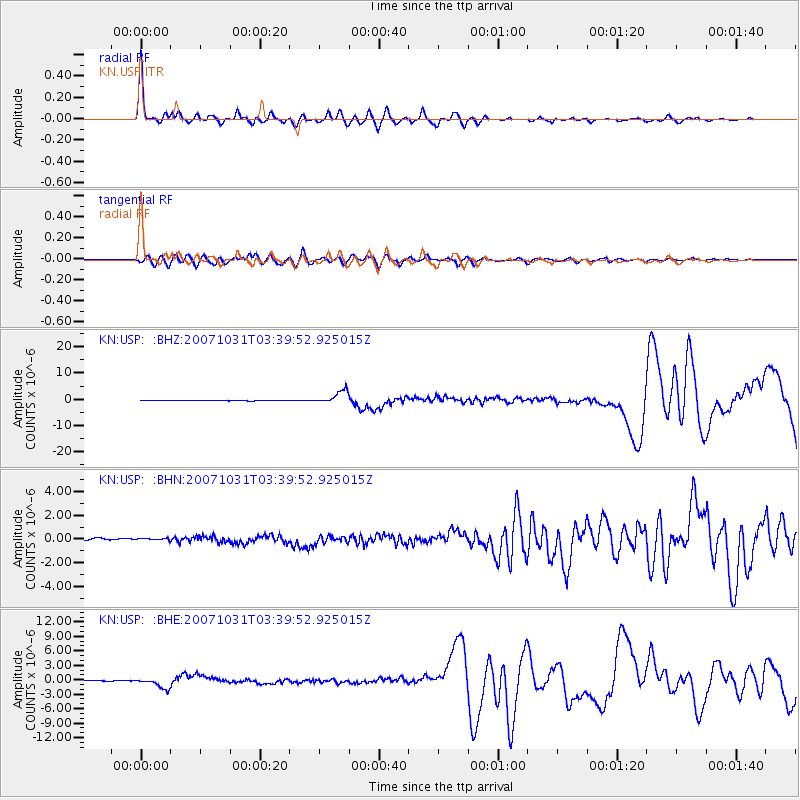
| Radial Match: |
98.15432 % |
| Radial Bump: |
337 |
| Transverse Match: |
92.80479 % |
| Transverse Bump: |
400 |
| SOD ConfigId: |
2564 |
| Insert Time: |
2010-03-08 22:14:05.608 +0000 |
| GWidth: |
2.5 |
| Max Bumps: |
400 |
| Tol: |
0.001 |
|
Signal To Noise
| Channel | StoN | STA | LTA |
| KN:USP: :BHN:20071031T03:39:52.925015Z | 1.2434385 | 2.1272322E-7 | 1.7107659E-7 |
| KN:USP: :BHE:20071031T03:39:52.925015Z | 15.588079 | 1.1308036E-6 | 7.2542846E-8 |
| KN:USP: :BHZ:20071031T03:39:52.925015Z | 45.655083 | 2.4764945E-6 | 5.4243568E-8 |
| Arrivals |
| Ps | 4.2 SECOND |
| PpPs | 16 SECOND |
| PsPs/PpSs | 21 SECOND |


