You are here: Home > Network List > AV - Alaska Volcano Observatory Stations List
> Station SPCR Ckakachatna River, Mount Spurr, Alaska > Earthquake Result Viewer
SPCR Ckakachatna River, Mount Spurr, Alaska - Earthquake Result Viewer

| Earthquake location: |
Xizang |
| Earthquake latitude/longitude: |
35.6/82.5 |
| Earthquake time(UTC): |
2020/06/25 (177) 21:05:18 GMT |
| Earthquake Depth: |
10 km |
| Earthquake Magnitude: |
6.4 Mww |
| Earthquake Catalog/Contributor: |
NEIC PDE/us |
|
| Network: |
AV Alaska Volcano Observatory |
| Station: |
SPCR Ckakachatna River, Mount Spurr, Alaska |
| Lat/Lon: |
61.20 N/152.21 W |
| Elevation: |
984 m |
|
| Distance: |
73.8 deg |
| Az: |
24.292 deg |
| Baz: |
316.204 deg |
| Ray Param: |
0.052779995 |
| Estimated Moho Depth: |
56.25 km |
| Estimated Crust Vp/Vs: |
1.85 |
| Assumed Crust Vp: |
6.566 km/s |
| Estimated Crust Vs: |
3.549 km/s |
| Estimated Crust Poisson's Ratio: |
0.29 |
|
| Radial Match: |
81.17925 % |
| Radial Bump: |
400 |
| Transverse Match: |
74.32131 % |
| Transverse Bump: |
400 |
| SOD ConfigId: |
21709731 |
| Insert Time: |
2020-07-09 21:11:45.945 +0000 |
| GWidth: |
2.5 |
| Max Bumps: |
400 |
| Tol: |
0.001 |
|
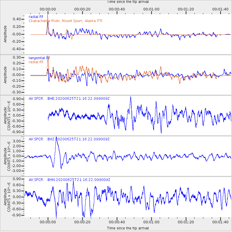
Signal To Noise
| Channel | StoN | STA | LTA |
| AV:SPCR: :BHZ:20200625T21:16:22.099009Z | 12.668536 | 1.4034595E-6 | 1.10783084E-7 |
| AV:SPCR: :BHN:20200625T21:16:22.099009Z | 1.891132 | 3.268899E-7 | 1.7285409E-7 |
| AV:SPCR: :BHE:20200625T21:16:22.099009Z | 1.4821846 | 2.221191E-7 | 1.4985926E-7 |
| Arrivals |
| Ps | 7.5 SECOND |
| PpPs | 24 SECOND |
| PsPs/PpSs | 31 SECOND |


