You are here: Home > Network List > US - United States National Seismic Network Stations List
> Station DGMT Dagmar, Montana, USA > Earthquake Result Viewer
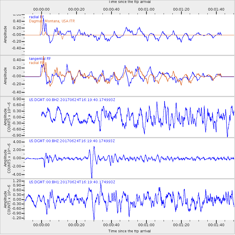
DGMT Dagmar, Montana, USA - Earthquake Result Viewer
*The percent match for this event was below the threshold and hence no stack was calculated.
| Earthquake location: |
Southern Peru |
| Earthquake latitude/longitude: |
-15.5/-73.5 |
| Earthquake time(UTC): |
2017/06/24 (175) 16:09:11 GMT |
| Earthquake Depth: |
69 km |
| Earthquake Magnitude: |
5.7 Mww |
| Earthquake Catalog/Contributor: |
NEIC PDE/us |
|
| Network: |
US United States National Seismic Network |
| Station: |
DGMT Dagmar, Montana, USA |
| Lat/Lon: |
48.47 N/104.20 W |
| Elevation: |
0.0 m |
|
| Distance: |
69.3 deg |
| Az: |
338.672 deg |
| Baz: |
148.2 deg |
| Ray Param: |
$rayparam |
*The percent match for this event was below the threshold and hence was not used in the summary stack. |
|
| Radial Match: |
62.48809 % |
| Radial Bump: |
400 |
| Transverse Match: |
55.860016 % |
| Transverse Bump: |
400 |
| SOD ConfigId: |
2140511 |
| Insert Time: |
2017-07-08 08:04:50.579 +0000 |
| GWidth: |
2.5 |
| Max Bumps: |
400 |
| Tol: |
0.001 |
|
Signal To Noise
| Channel | StoN | STA | LTA |
| US:DGMT:00:BHZ:20170624T16:19:40.174993Z | 6.040807 | 6.951522E-7 | 1.15076055E-7 |
| US:DGMT:00:BH1:20170624T16:19:40.174993Z | 1.3705012 | 3.266835E-7 | 2.3836792E-7 |
| US:DGMT:00:BH2:20170624T16:19:40.174993Z | 1.3381606 | 3.0496366E-7 | 2.2789766E-7 |
| Arrivals |
| Ps | |
| PpPs | |
| PsPs/PpSs | |


