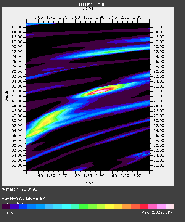
USP KN.USP - Earthquake Result Viewer
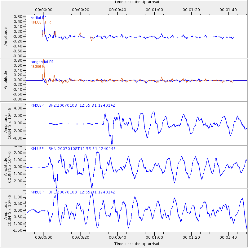
Earthquake location: Nicobar Islands, India Region
Earthquake latitude/longitude: 8.1/92.4
Earthquake time(UTC): 2007/01/08 (008) 12:48:40 GMT
Earthquake Depth: 11 km
Earthquake Magnitude: 5.7 MB, 6.2 MS, 6.1 MW, 6.1 MW
Earthquake Catalog/Contributor: WHDF/NEIC
Network: KN Kyrgyz Seismic Telemetry Network
Station: USP KN.USP
Lat/Lon: 43.27 N/74.50 E
Elevation: 740 m
Distance: 38.4 deg
Az: 338.776 deg
Baz: 150.61 deg
Ray Param: 0.075569995
Estimated Moho Depth: 38.0 km
Estimated Crust Vp/Vs: 1.89
Assumed Crust Vp: 6.306 km/s
Estimated Crust Vs: 3.328 km/s
Estimated Crust Poisson's Ratio: 0.31
Radial Match: 96.89927 %
Radial Bump: 272
Transverse Match: 90.35136 %
Transverse Bump: 400
SOD ConfigId: 2564
Insert Time: 2010-03-08 22:15:45.572 +0000
GWidth: 2.5
Max Bumps: 400
Tol: 0.001

Signal To Noise

ChannelStoNSTALTA
KN:USP: :BHN:20070108T12:55:31.124014Z7.28103885.599395E-77.6903795E-8
KN:USP: :BHE:20070108T12:55:31.124014Z3.9178113.5222547E-78.9903644E-8
KN:USP: :BHZ:20070108T12:55:31.124014Z15.166771.033563E-66.814655E-8
Arrivals
Ps5.8 SECOND
PpPs16 SECOND
PsPs/PpSs22 SECOND