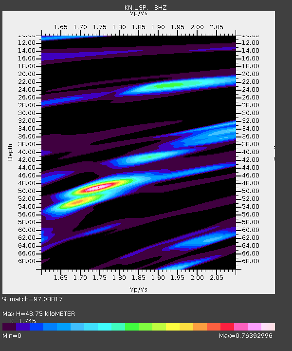
USP KN.USP - Earthquake Result Viewer
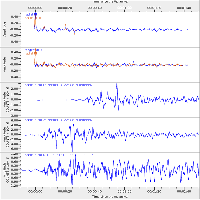
Earthquake location: Irian Jaya Region, Indonesia
Earthquake latitude/longitude: -3.1/136.0
Earthquake time(UTC): 1994/04/13 (103) 22:22:29 GMT
Earthquake Depth: 20 km
Earthquake Magnitude: 6.0 MB, 6.5 MS, 6.5 UNKNOWN, 6.5 MW
Earthquake Catalog/Contributor: WHDF/NEIC
Network: KN Kyrgyz Seismic Telemetry Network
Station: USP KN.USP
Lat/Lon: 43.27 N/74.50 E
Elevation: 740 m
Distance: 71.8 deg
Az: 317.517 deg
Baz: 112.595 deg
Ray Param: 0.05403826
Estimated Moho Depth: 48.75 km
Estimated Crust Vp/Vs: 1.75
Assumed Crust Vp: 6.306 km/s
Estimated Crust Vs: 3.614 km/s
Estimated Crust Poisson's Ratio: 0.26
Radial Match: 97.08817 %
Radial Bump: 285
Transverse Match: 92.702866 %
Transverse Bump: 400
SOD ConfigId: 4480
Insert Time: 2010-03-08 22:15:55.311 +0000
GWidth: 2.5
Max Bumps: 400
Tol: 0.001

Signal To Noise

ChannelStoNSTALTA
KN:USP: :BHZ:19940413T22:33:19.098999Z3.86610722.658711E-76.8769715E-8
KN:USP: :BHN:19940413T22:33:19.098999Z1.5790217.100533E-84.4967944E-8
KN:USP: :BHE:19940413T22:33:19.098999Z4.303561.2442393E-72.8911863E-8
Arrivals
Ps6.0 SECOND
PpPs20 SECOND
PsPs/PpSs26 SECOND