You are here: Home > Network List > KN - Kyrgyz Seismic Telemetry Network Stations List
> Station USP KN.USP > Earthquake Result Viewer
USP KN.USP - Earthquake Result Viewer
| Earthquake location: |
Banda Sea |
| Earthquake latitude/longitude: |
-7.5/127.9 |
| Earthquake time(UTC): |
1994/07/13 (194) 11:45:25 GMT |
| Earthquake Depth: |
185 km |
| Earthquake Magnitude: |
6.4 MB, 6.8 UNKNOWN, 6.5 MW |
| Earthquake Catalog/Contributor: |
WHDF/NEIC |
|
| Network: |
KN Kyrgyz Seismic Telemetry Network |
| Station: |
USP KN.USP |
| Lat/Lon: |
43.27 N/74.50 E |
| Elevation: |
740 m |
|
| Distance: |
69.9 deg |
| Az: |
321.354 deg |
| Baz: |
122.033 deg |
| Ray Param: |
0.054802574 |
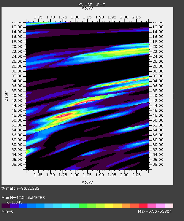
| Estimated Moho Depth: |
42.5 km |
| Estimated Crust Vp/Vs: |
1.85 |
| Assumed Crust Vp: |
6.306 km/s |
| Estimated Crust Vs: |
3.418 km/s |
| Estimated Crust Poisson's Ratio: |
0.29 |
|
| Radial Match: |
96.21282 % |
| Radial Bump: |
276 |
| Transverse Match: |
83.96828 % |
| Transverse Bump: |
364 |
| SOD ConfigId: |
4480 |
| Insert Time: |
2010-03-08 22:16:14.724 +0000 |
| GWidth: |
2.5 |
| Max Bumps: |
400 |
| Tol: |
0.001 |
|
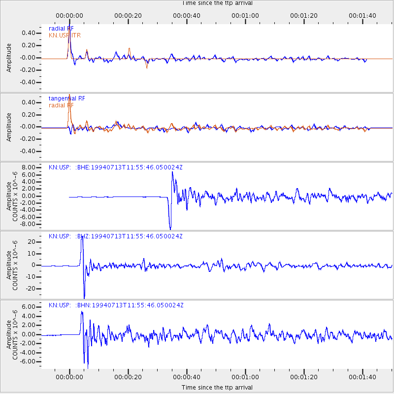
Signal To Noise
| Channel | StoN | STA | LTA |
| KN:USP: :BHZ:19940713T11:55:46.050024Z | 231.10081 | 8.86477E-6 | 3.8358888E-8 |
| KN:USP: :BHN:19940713T11:55:46.050024Z | 15.935273 | 1.8197824E-6 | 1.14198386E-7 |
| KN:USP: :BHE:19940713T11:55:46.050024Z | 53.977215 | 3.0882088E-6 | 5.7213192E-8 |
| Arrivals |
| Ps | 5.9 SECOND |
| PpPs | 19 SECOND |
| PsPs/PpSs | 24 SECOND |


