You are here: Home > Network List > KN - Kyrgyz Seismic Telemetry Network Stations List
> Station USP KN.USP > Earthquake Result Viewer
USP KN.USP - Earthquake Result Viewer
| Earthquake location: |
South Of Java, Indonesia |
| Earthquake latitude/longitude: |
-10.2/110.6 |
| Earthquake time(UTC): |
2009/09/07 (250) 16:12:22 GMT |
| Earthquake Depth: |
23 km |
| Earthquake Magnitude: |
6.1 MB, 5.9 MS, 6.2 MW, 6.1 MW |
| Earthquake Catalog/Contributor: |
WHDF/NEIC |
|
| Network: |
KN Kyrgyz Seismic Telemetry Network |
| Station: |
USP KN.USP |
| Lat/Lon: |
43.27 N/74.50 E |
| Elevation: |
740 m |
|
| Distance: |
62.6 deg |
| Az: |
330.973 deg |
| Baz: |
139.162 deg |
| Ray Param: |
0.060109664 |
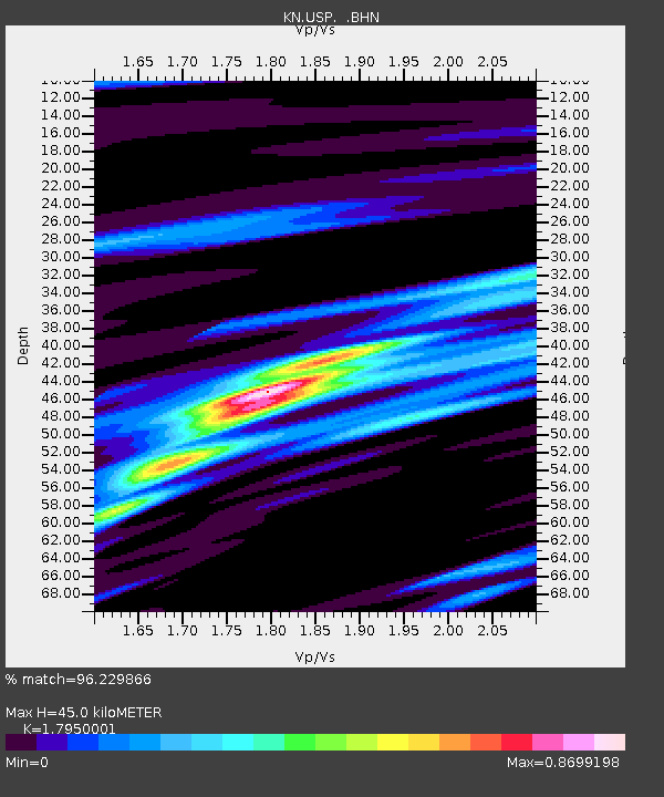
| Estimated Moho Depth: |
45.0 km |
| Estimated Crust Vp/Vs: |
1.80 |
| Assumed Crust Vp: |
6.306 km/s |
| Estimated Crust Vs: |
3.513 km/s |
| Estimated Crust Poisson's Ratio: |
0.27 |
|
| Radial Match: |
96.229866 % |
| Radial Bump: |
357 |
| Transverse Match: |
86.858215 % |
| Transverse Bump: |
400 |
| SOD ConfigId: |
2622 |
| Insert Time: |
2010-03-08 22:16:53.039 +0000 |
| GWidth: |
2.5 |
| Max Bumps: |
400 |
| Tol: |
0.001 |
|
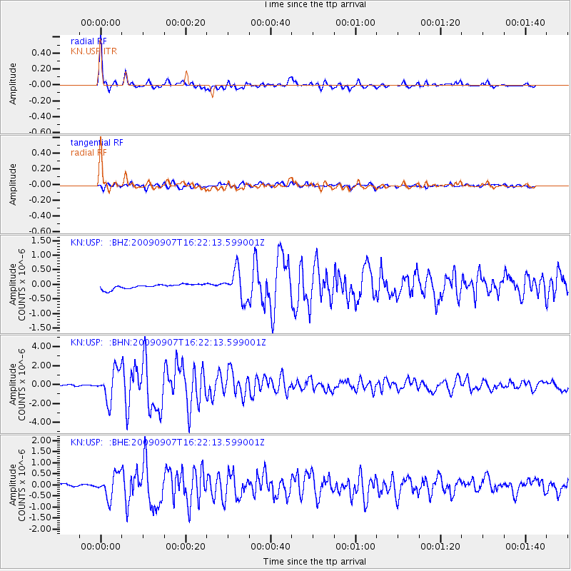
Signal To Noise
| Channel | StoN | STA | LTA |
| KN:USP: :BHN:20090907T16:22:13.599001Z | 26.947824 | 1.6673501E-6 | 6.187327E-8 |
| KN:USP: :BHE:20090907T16:22:13.599001Z | 8.275732 | 5.453702E-7 | 6.589993E-8 |
| KN:USP: :BHZ:20090907T16:22:13.599001Z | 6.6158643 | 5.241511E-7 | 7.92264E-8 |
| Arrivals |
| Ps | 5.9 SECOND |
| PpPs | 19 SECOND |
| PsPs/PpSs | 25 SECOND |


