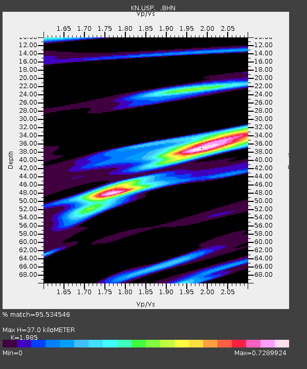
USP KN.USP - Earthquake Result Viewer
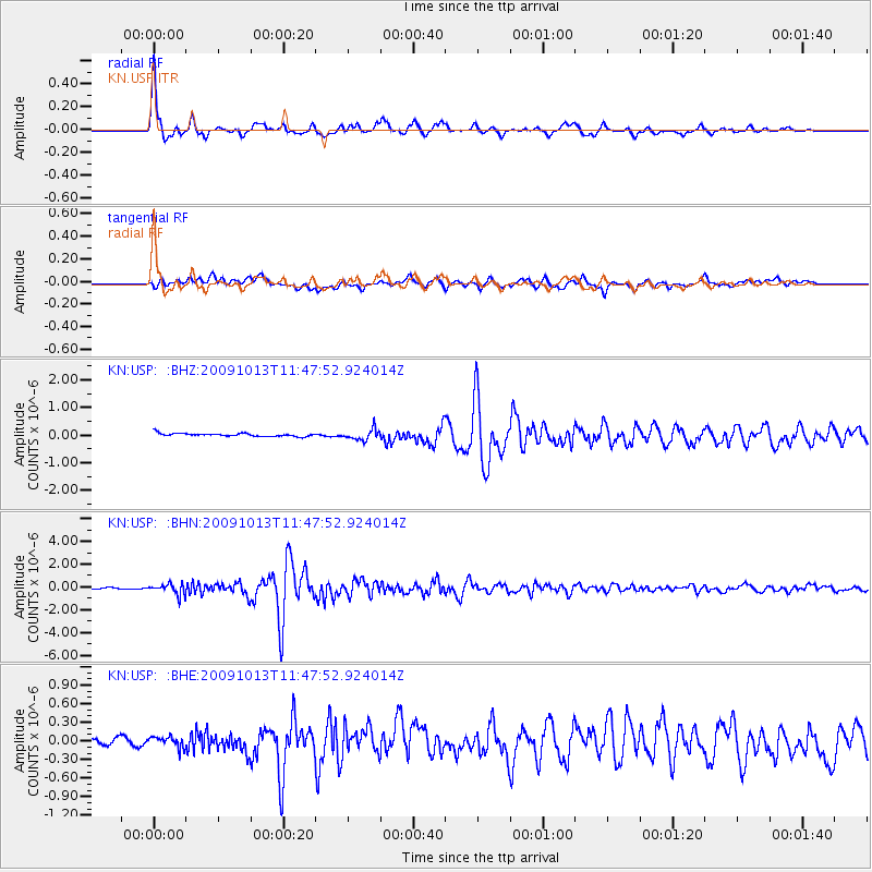
Earthquake location: Halmahera, Indonesia
Earthquake latitude/longitude: 2.9/128.2
Earthquake time(UTC): 2009/10/13 (286) 11:38:05 GMT
Earthquake Depth: 32 km
Earthquake Magnitude: 5.8 MB, 5.6 MS, 6.0 MW, 6.0 MW
Earthquake Catalog/Contributor: WHDF/NEIC
Network: KN Kyrgyz Seismic Telemetry Network
Station: USP KN.USP
Lat/Lon: 43.27 N/74.50 E
Elevation: 740 m
Distance: 62.2 deg
Az: 318.262 deg
Baz: 114.467 deg
Ray Param: 0.06032402
Estimated Moho Depth: 37.0 km
Estimated Crust Vp/Vs: 1.99
Assumed Crust Vp: 6.306 km/s
Estimated Crust Vs: 3.177 km/s
Estimated Crust Poisson's Ratio: 0.33
Radial Match: 95.534546 %
Radial Bump: 400
Transverse Match: 80.78441 %
Transverse Bump: 400
SOD ConfigId: 2622
Insert Time: 2010-03-08 22:17:04.545 +0000
GWidth: 2.5
Max Bumps: 400
Tol: 0.001

Signal To Noise

ChannelStoNSTALTA
KN:USP: :BHN:20091013T11:47:52.924014Z7.89853334.6052887E-75.830562E-8
KN:USP: :BHE:20091013T11:47:52.924014Z1.00642628.920944E-88.863982E-8
KN:USP: :BHZ:20091013T11:47:52.924014Z3.45834041.9611436E-75.670765E-8
Arrivals
Ps6.0 SECOND
PpPs17 SECOND
PsPs/PpSs23 SECOND