You are here: Home > Network List > KN - Kyrgyz Seismic Telemetry Network Stations List
> Station USP KN.USP > Earthquake Result Viewer
USP KN.USP - Earthquake Result Viewer
| Earthquake location: |
Banda Sea |
| Earthquake latitude/longitude: |
-6.1/130.4 |
| Earthquake time(UTC): |
2009/10/24 (297) 14:40:43 GMT |
| Earthquake Depth: |
130 km |
| Earthquake Magnitude: |
6.7 MB, 6.9 MW, 6.9 MW |
| Earthquake Catalog/Contributor: |
WHDF/NEIC |
|
| Network: |
KN Kyrgyz Seismic Telemetry Network |
| Station: |
USP KN.USP |
| Lat/Lon: |
43.27 N/74.50 E |
| Elevation: |
740 m |
|
| Distance: |
70.4 deg |
| Az: |
320.072 deg |
| Baz: |
119.11 deg |
| Ray Param: |
0.054645397 |
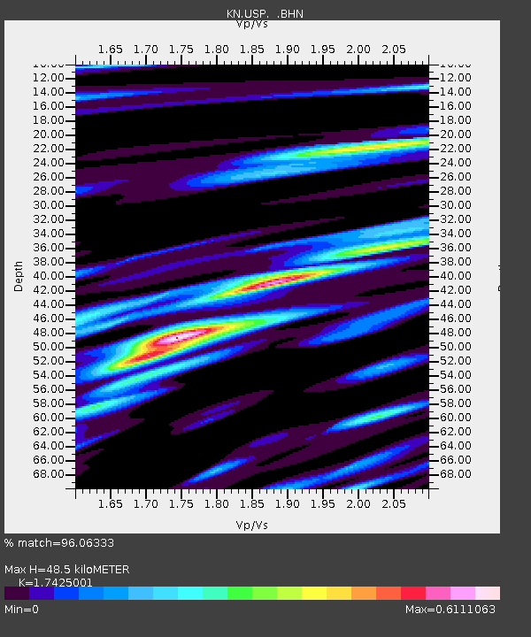
| Estimated Moho Depth: |
48.5 km |
| Estimated Crust Vp/Vs: |
1.74 |
| Assumed Crust Vp: |
6.306 km/s |
| Estimated Crust Vs: |
3.619 km/s |
| Estimated Crust Poisson's Ratio: |
0.25 |
|
| Radial Match: |
96.06333 % |
| Radial Bump: |
400 |
| Transverse Match: |
87.31435 % |
| Transverse Bump: |
400 |
| SOD ConfigId: |
2622 |
| Insert Time: |
2010-03-08 22:17:10.367 +0000 |
| GWidth: |
2.5 |
| Max Bumps: |
400 |
| Tol: |
0.001 |
|
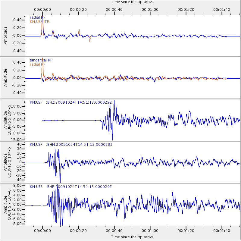
Signal To Noise
| Channel | StoN | STA | LTA |
| KN:USP: :BHN:20091024T14:51:13.000029Z | 87.20669 | 6.61482E-6 | 7.585221E-8 |
| KN:USP: :BHE:20091024T14:51:13.000029Z | 37.038902 | 1.2904992E-6 | 3.4841726E-8 |
| KN:USP: :BHZ:20091024T14:51:13.000029Z | 32.20036 | 1.9724878E-6 | 6.12567E-8 |
| Arrivals |
| Ps | 5.9 SECOND |
| PpPs | 20 SECOND |
| PsPs/PpSs | 26 SECOND |


