You are here: Home > Network List > TA - USArray Transportable Network (new EarthScope stations) Stations List
> Station F20K Avaraart Lake, AK, USA > Earthquake Result Viewer
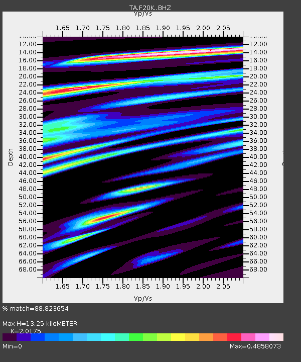
F20K Avaraart Lake, AK, USA - Earthquake Result Viewer
| Earthquake location: |
Xizang |
| Earthquake latitude/longitude: |
35.6/82.5 |
| Earthquake time(UTC): |
2020/06/25 (177) 21:05:18 GMT |
| Earthquake Depth: |
10 km |
| Earthquake Magnitude: |
6.4 Mww |
| Earthquake Catalog/Contributor: |
NEIC PDE/us |
|
| Network: |
TA USArray Transportable Network (new EarthScope stations) |
| Station: |
F20K Avaraart Lake, AK, USA |
| Lat/Lon: |
67.05 N/155.73 W |
| Elevation: |
136 m |
|
| Distance: |
68.6 deg |
| Az: |
20.973 deg |
| Baz: |
311.969 deg |
| Ray Param: |
0.05620805 |
| Estimated Moho Depth: |
13.25 km |
| Estimated Crust Vp/Vs: |
2.02 |
| Assumed Crust Vp: |
6.522 km/s |
| Estimated Crust Vs: |
3.233 km/s |
| Estimated Crust Poisson's Ratio: |
0.34 |
|
| Radial Match: |
88.823654 % |
| Radial Bump: |
400 |
| Transverse Match: |
79.36469 % |
| Transverse Bump: |
400 |
| SOD ConfigId: |
21709731 |
| Insert Time: |
2020-07-09 21:23:34.436 +0000 |
| GWidth: |
2.5 |
| Max Bumps: |
400 |
| Tol: |
0.001 |
|

Signal To Noise
| Channel | StoN | STA | LTA |
| TA:F20K: :BHZ:20200625T21:15:50.724985Z | 23.628115 | 1.1677021E-6 | 4.942003E-8 |
| TA:F20K: :BHN:20200625T21:15:50.724985Z | 10.115858 | 2.8288824E-7 | 2.7964829E-8 |
| TA:F20K: :BHE:20200625T21:15:50.724985Z | 9.884966 | 3.301988E-7 | 3.3404138E-8 |
| Arrivals |
| Ps | 2.1 SECOND |
| PpPs | 5.9 SECOND |
| PsPs/PpSs | 8.1 SECOND |


