You are here: Home > Network List > TA - USArray Transportable Network (new EarthScope stations) Stations List
> Station G21K Allakaket, AK, USA > Earthquake Result Viewer
G21K Allakaket, AK, USA - Earthquake Result Viewer
| Earthquake location: |
Xizang |
| Earthquake latitude/longitude: |
35.6/82.5 |
| Earthquake time(UTC): |
2020/06/25 (177) 21:05:18 GMT |
| Earthquake Depth: |
10 km |
| Earthquake Magnitude: |
6.4 Mww |
| Earthquake Catalog/Contributor: |
NEIC PDE/us |
|
| Network: |
TA USArray Transportable Network (new EarthScope stations) |
| Station: |
G21K Allakaket, AK, USA |
| Lat/Lon: |
66.52 N/153.51 W |
| Elevation: |
446 m |
|
| Distance: |
69.6 deg |
| Az: |
20.75 deg |
| Baz: |
313.927 deg |
| Ray Param: |
0.055540986 |
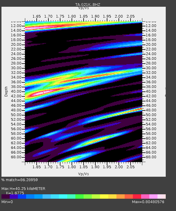
| Estimated Moho Depth: |
40.25 km |
| Estimated Crust Vp/Vs: |
1.68 |
| Assumed Crust Vp: |
6.455 km/s |
| Estimated Crust Vs: |
3.848 km/s |
| Estimated Crust Poisson's Ratio: |
0.22 |
|
| Radial Match: |
86.28959 % |
| Radial Bump: |
400 |
| Transverse Match: |
80.08203 % |
| Transverse Bump: |
400 |
| SOD ConfigId: |
21709731 |
| Insert Time: |
2020-07-09 21:23:54.525 +0000 |
| GWidth: |
2.5 |
| Max Bumps: |
400 |
| Tol: |
0.001 |
|
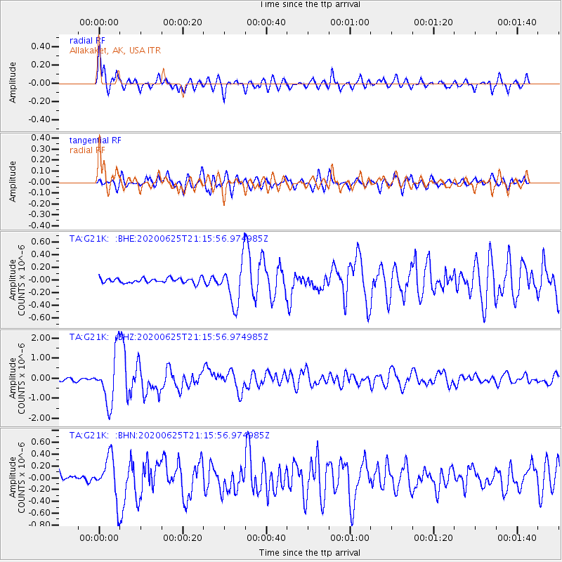
Signal To Noise
| Channel | StoN | STA | LTA |
| TA:G21K: :BHZ:20200625T21:15:56.974985Z | 20.917858 | 1.2962514E-6 | 6.196865E-8 |
| TA:G21K: :BHN:20200625T21:15:56.974985Z | 6.5678267 | 3.6648208E-7 | 5.5799596E-8 |
| TA:G21K: :BHE:20200625T21:15:56.974985Z | 9.342586 | 3.4914035E-7 | 3.737085E-8 |
| Arrivals |
| Ps | 4.4 SECOND |
| PpPs | 16 SECOND |
| PsPs/PpSs | 20 SECOND |


