You are here: Home > Network List > TA - USArray Transportable Network (new EarthScope stations) Stations List
> Station M15K Kasigluk River, AK, USA > Earthquake Result Viewer
M15K Kasigluk River, AK, USA - Earthquake Result Viewer
| Earthquake location: |
Xizang |
| Earthquake latitude/longitude: |
35.6/82.5 |
| Earthquake time(UTC): |
2020/06/25 (177) 21:05:18 GMT |
| Earthquake Depth: |
10 km |
| Earthquake Magnitude: |
6.4 Mww |
| Earthquake Catalog/Contributor: |
NEIC PDE/us |
|
| Network: |
TA USArray Transportable Network (new EarthScope stations) |
| Station: |
M15K Kasigluk River, AK, USA |
| Lat/Lon: |
60.69 N/160.69 W |
| Elevation: |
210 m |
|
| Distance: |
71.1 deg |
| Az: |
27.638 deg |
| Baz: |
309.811 deg |
| Ray Param: |
0.05454157 |
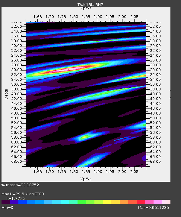
| Estimated Moho Depth: |
29.5 km |
| Estimated Crust Vp/Vs: |
1.78 |
| Assumed Crust Vp: |
6.182 km/s |
| Estimated Crust Vs: |
3.478 km/s |
| Estimated Crust Poisson's Ratio: |
0.27 |
|
| Radial Match: |
93.10752 % |
| Radial Bump: |
400 |
| Transverse Match: |
81.71201 % |
| Transverse Bump: |
400 |
| SOD ConfigId: |
21709731 |
| Insert Time: |
2020-07-09 21:24:47.369 +0000 |
| GWidth: |
2.5 |
| Max Bumps: |
400 |
| Tol: |
0.001 |
|

Signal To Noise
| Channel | StoN | STA | LTA |
| TA:M15K: :BHZ:20200625T21:16:06.149973Z | 15.423905 | 1.1563401E-6 | 7.497064E-8 |
| TA:M15K: :BHN:20200625T21:16:06.149973Z | 3.6199512 | 4.2788292E-7 | 1.182013E-7 |
| TA:M15K: :BHE:20200625T21:16:06.149973Z | 4.8119273 | 4.6904728E-7 | 9.747597E-8 |
| Arrivals |
| Ps | 3.8 SECOND |
| PpPs | 13 SECOND |
| PsPs/PpSs | 17 SECOND |


