You are here: Home > Network List > TA - USArray Transportable Network (new EarthScope stations) Stations List
> Station M17K Holitna River, AK, USA > Earthquake Result Viewer
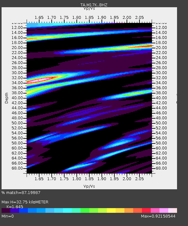
M17K Holitna River, AK, USA - Earthquake Result Viewer
| Earthquake location: |
Xizang |
| Earthquake latitude/longitude: |
35.6/82.5 |
| Earthquake time(UTC): |
2020/06/25 (177) 21:05:18 GMT |
| Earthquake Depth: |
10 km |
| Earthquake Magnitude: |
6.4 Mww |
| Earthquake Catalog/Contributor: |
NEIC PDE/us |
|
| Network: |
TA USArray Transportable Network (new EarthScope stations) |
| Station: |
M17K Holitna River, AK, USA |
| Lat/Lon: |
61.40 N/157.44 W |
| Elevation: |
387 m |
|
| Distance: |
71.8 deg |
| Az: |
25.98 deg |
| Baz: |
312.124 deg |
| Ray Param: |
0.054074023 |
| Estimated Moho Depth: |
32.75 km |
| Estimated Crust Vp/Vs: |
1.64 |
| Assumed Crust Vp: |
6.155 km/s |
| Estimated Crust Vs: |
3.742 km/s |
| Estimated Crust Poisson's Ratio: |
0.21 |
|
| Radial Match: |
87.19987 % |
| Radial Bump: |
400 |
| Transverse Match: |
77.36643 % |
| Transverse Bump: |
400 |
| SOD ConfigId: |
21709731 |
| Insert Time: |
2020-07-09 21:24:50.359 +0000 |
| GWidth: |
2.5 |
| Max Bumps: |
400 |
| Tol: |
0.001 |
|

Signal To Noise
| Channel | StoN | STA | LTA |
| TA:M17K: :BHZ:20200625T21:16:10.549998Z | 12.478456 | 1.3490569E-6 | 1.0811088E-7 |
| TA:M17K: :BHN:20200625T21:16:10.549998Z | 2.64979 | 4.349432E-7 | 1.641425E-7 |
| TA:M17K: :BHE:20200625T21:16:10.549998Z | 2.1730688 | 3.9128042E-7 | 1.8005893E-7 |
| Arrivals |
| Ps | 3.6 SECOND |
| PpPs | 14 SECOND |
| PsPs/PpSs | 17 SECOND |


