You are here: Home > Network List > TA - USArray Transportable Network (new EarthScope stations) Stations List
> Station M31M Drury Creek, Yukon, CA > Earthquake Result Viewer
M31M Drury Creek, Yukon, CA - Earthquake Result Viewer

| Earthquake location: |
Xizang |
| Earthquake latitude/longitude: |
35.6/82.5 |
| Earthquake time(UTC): |
2020/06/25 (177) 21:05:18 GMT |
| Earthquake Depth: |
10 km |
| Earthquake Magnitude: |
6.4 Mww |
| Earthquake Catalog/Contributor: |
NEIC PDE/us |
|
| Network: |
TA USArray Transportable Network (new EarthScope stations) |
| Station: |
M31M Drury Creek, Yukon, CA |
| Lat/Lon: |
62.20 N/134.39 W |
| Elevation: |
639 m |
|
| Distance: |
78.1 deg |
| Az: |
16.697 deg |
| Baz: |
330.049 deg |
| Ray Param: |
0.049898807 |
| Estimated Moho Depth: |
69.25 km |
| Estimated Crust Vp/Vs: |
1.78 |
| Assumed Crust Vp: |
6.419 km/s |
| Estimated Crust Vs: |
3.606 km/s |
| Estimated Crust Poisson's Ratio: |
0.27 |
|
| Radial Match: |
92.40362 % |
| Radial Bump: |
400 |
| Transverse Match: |
82.24255 % |
| Transverse Bump: |
400 |
| SOD ConfigId: |
21709731 |
| Insert Time: |
2020-07-09 21:24:58.969 +0000 |
| GWidth: |
2.5 |
| Max Bumps: |
400 |
| Tol: |
0.001 |
|
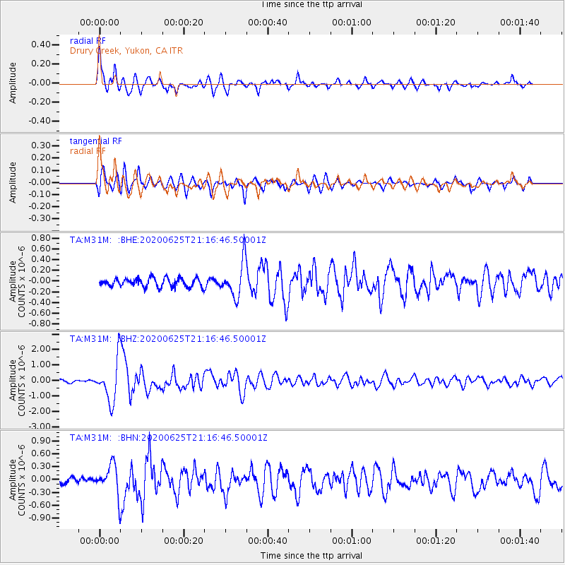
Signal To Noise
| Channel | StoN | STA | LTA |
| TA:M31M: :BHZ:20200625T21:16:46.50001Z | 16.554972 | 1.3869453E-6 | 8.3778176E-8 |
| TA:M31M: :BHN:20200625T21:16:46.50001Z | 5.6061335 | 3.52592E-7 | 6.2893974E-8 |
| TA:M31M: :BHE:20200625T21:16:46.50001Z | 4.3274117 | 3.415888E-7 | 7.8936054E-8 |
| Arrivals |
| Ps | 8.7 SECOND |
| PpPs | 29 SECOND |
| PsPs/PpSs | 38 SECOND |


