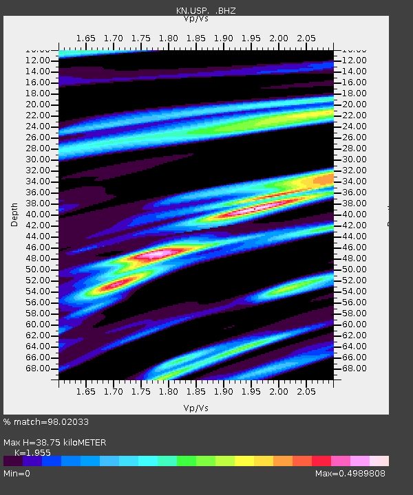
USP KN.USP - Earthquake Result Viewer
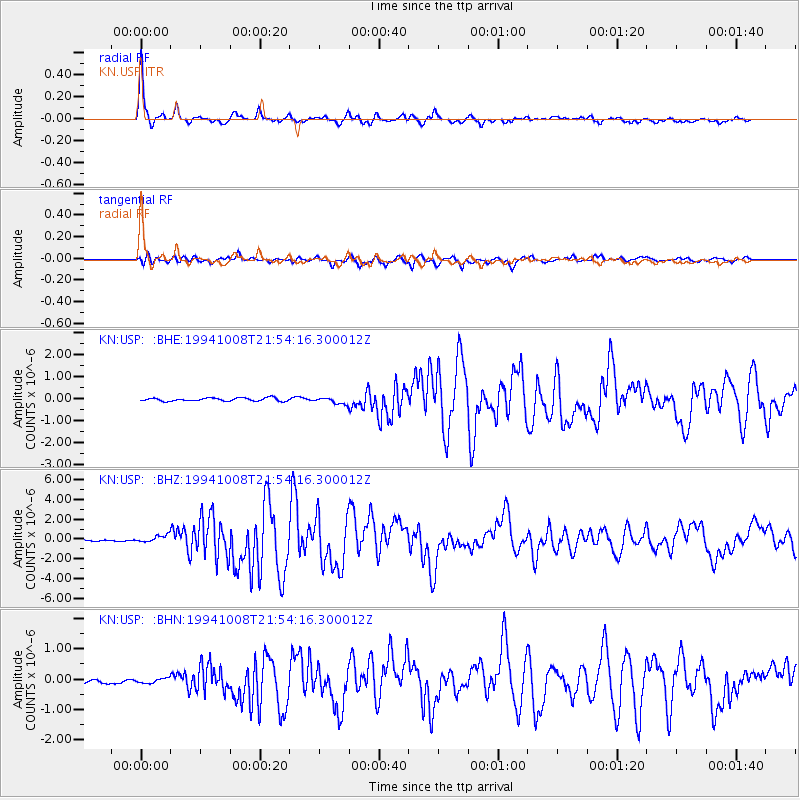
Earthquake location: Halmahera, Indonesia
Earthquake latitude/longitude: -1.2/128.0
Earthquake time(UTC): 1994/10/08 (281) 21:44:09 GMT
Earthquake Depth: 31 km
Earthquake Magnitude: 6.3 MB, 6.8 MS, 6.8 UNKNOWN, 6.9 MW
Earthquake Catalog/Contributor: WHDF/NEIC
Network: KN Kyrgyz Seismic Telemetry Network
Station: USP KN.USP
Lat/Lon: 43.27 N/74.50 E
Elevation: 740 m
Distance: 65.2 deg
Az: 319.687 deg
Baz: 117.689 deg
Ray Param: 0.058403026
Estimated Moho Depth: 38.75 km
Estimated Crust Vp/Vs: 1.96
Assumed Crust Vp: 6.306 km/s
Estimated Crust Vs: 3.226 km/s
Estimated Crust Poisson's Ratio: 0.32
Radial Match: 98.02033 %
Radial Bump: 311
Transverse Match: 90.67693 %
Transverse Bump: 400
SOD ConfigId: 4480
Insert Time: 2010-03-08 22:18:00.194 +0000
GWidth: 2.5
Max Bumps: 400
Tol: 0.001

Signal To Noise

ChannelStoNSTALTA
KN:USP: :BHZ:19941008T21:54:16.300012Z6.60563663.753152E-75.681742E-8
KN:USP: :BHN:19941008T21:54:16.300012Z1.18648788.413615E-87.091194E-8
KN:USP: :BHE:19941008T21:54:16.300012Z2.11611271.50537E-77.113846E-8
Arrivals
Ps6.1 SECOND
PpPs18 SECOND
PsPs/PpSs24 SECOND