You are here: Home > Network List > GM - US Geological Survey Networks Stations List
> Station IWM01 Jericho 2M Well Monitoring Station > Earthquake Result Viewer
IWM01 Jericho 2M Well Monitoring Station - Earthquake Result Viewer
| Earthquake location: |
Southern Peru |
| Earthquake latitude/longitude: |
-15.5/-73.5 |
| Earthquake time(UTC): |
2017/06/24 (175) 16:09:11 GMT |
| Earthquake Depth: |
69 km |
| Earthquake Magnitude: |
5.7 Mww |
| Earthquake Catalog/Contributor: |
NEIC PDE/us |
|
| Network: |
GM US Geological Survey Networks |
| Station: |
IWM01 Jericho 2M Well Monitoring Station |
| Lat/Lon: |
36.73 N/96.53 W |
| Elevation: |
328 m |
|
| Distance: |
56.3 deg |
| Az: |
337.756 deg |
| Baz: |
152.978 deg |
| Ray Param: |
0.064044476 |
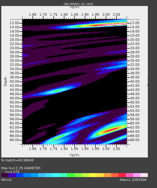
| Estimated Moho Depth: |
12.25 km |
| Estimated Crust Vp/Vs: |
2.08 |
| Assumed Crust Vp: |
6.483 km/s |
| Estimated Crust Vs: |
3.124 km/s |
| Estimated Crust Poisson's Ratio: |
0.35 |
|
| Radial Match: |
83.59948 % |
| Radial Bump: |
400 |
| Transverse Match: |
40.72424 % |
| Transverse Bump: |
400 |
| SOD ConfigId: |
2140511 |
| Insert Time: |
2017-07-08 08:08:12.235 +0000 |
| GWidth: |
2.5 |
| Max Bumps: |
400 |
| Tol: |
0.001 |
|
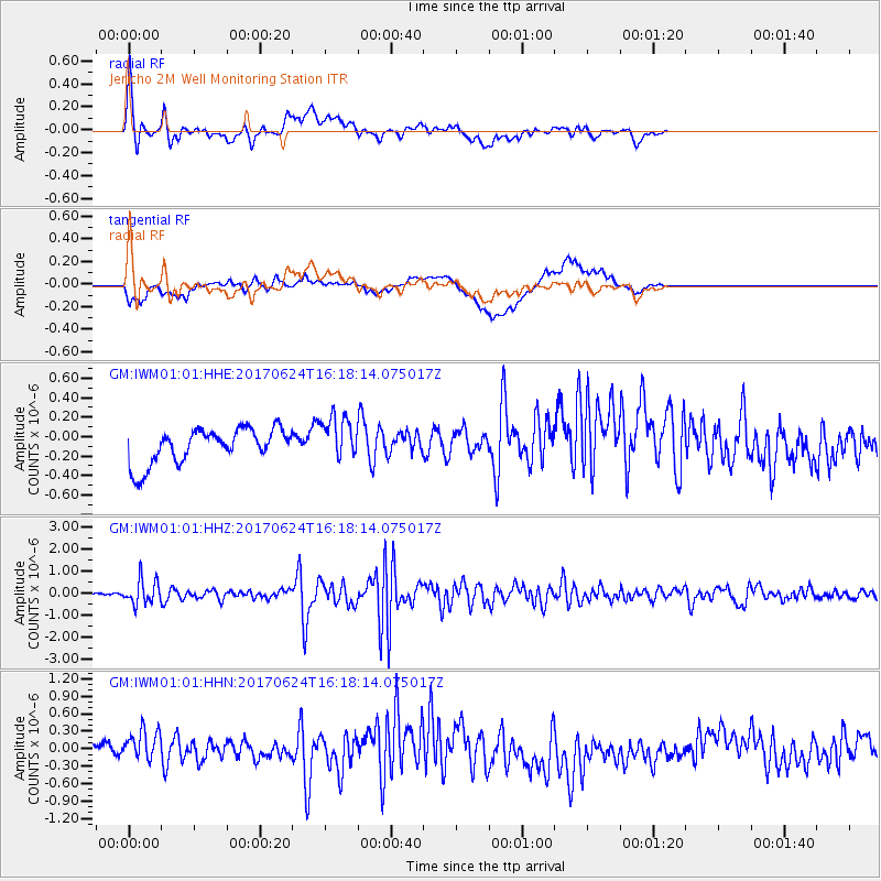
Signal To Noise
| Channel | StoN | STA | LTA |
| GM:IWM01:01:HHZ:20170624T16:18:14.075017Z | 4.503139 | 5.5342747E-7 | 1.2289816E-7 |
| GM:IWM01:01:HHN:20170624T16:18:14.075017Z | 1.7739723 | 3.3605525E-7 | 1.8943658E-7 |
| GM:IWM01:01:HHE:20170624T16:18:14.075017Z | 1.2733313 | 2.2841054E-7 | 1.793803E-7 |
| Arrivals |
| Ps | 2.1 SECOND |
| PpPs | 5.6 SECOND |
| PsPs/PpSs | 7.7 SECOND |


