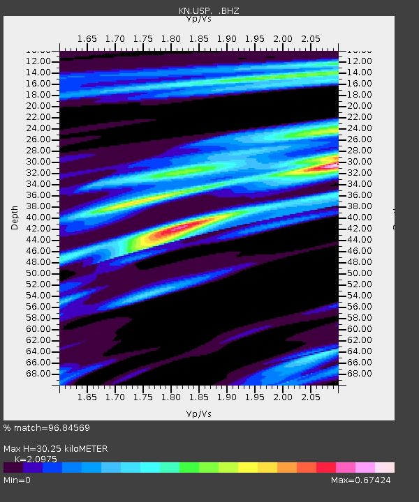
USP KN.USP - Earthquake Result Viewer
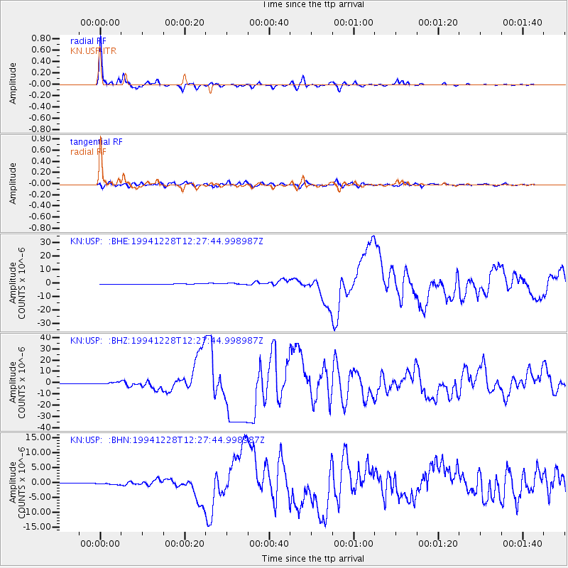
Earthquake location: Off East Coast Of Honshu, Japan
Earthquake latitude/longitude: 40.5/143.5
Earthquake time(UTC): 1994/12/28 (362) 12:19:23 GMT
Earthquake Depth: 33 km
Earthquake Magnitude: 6.4 MB, 7.5 MS, 7.2 UNKNOWN, 7.7 MW
Earthquake Catalog/Contributor: WHDF/NEIC
Network: KN Kyrgyz Seismic Telemetry Network
Station: USP KN.USP
Lat/Lon: 43.27 N/74.50 E
Elevation: 740 m
Distance: 50.1 deg
Az: 297.298 deg
Baz: 68.179 deg
Ray Param: 0.06820605
Estimated Moho Depth: 30.25 km
Estimated Crust Vp/Vs: 2.10
Assumed Crust Vp: 6.306 km/s
Estimated Crust Vs: 3.006 km/s
Estimated Crust Poisson's Ratio: 0.35
Radial Match: 96.84569 %
Radial Bump: 242
Transverse Match: 88.23574 %
Transverse Bump: 400
SOD ConfigId: 4480
Insert Time: 2010-03-08 22:18:43.038 +0000
GWidth: 2.5
Max Bumps: 400
Tol: 0.001

Signal To Noise

ChannelStoNSTALTA
KN:USP: :BHZ:19941228T12:27:44.998987Z5.0089441.0384916E-62.0732746E-7
KN:USP: :BHN:19941228T12:27:44.998987Z3.34152463.9923205E-71.1947601E-7
KN:USP: :BHE:19941228T12:27:44.998987Z2.8480074.780995E-71.6787159E-7
Arrivals
Ps5.5 SECOND
PpPs14 SECOND
PsPs/PpSs20 SECOND