You are here: Home > Network List > KN - Kyrgyz Seismic Telemetry Network Stations List
> Station USP KN.USP > Earthquake Result Viewer
USP KN.USP - Earthquake Result Viewer

| Earthquake location: |
Banda Sea |
| Earthquake latitude/longitude: |
-7.0/129.0 |
| Earthquake time(UTC): |
1998/11/09 (313) 05:30:14 GMT |
| Earthquake Depth: |
33 km |
| Earthquake Magnitude: |
6.1 MB, 6.7 UNKNOWN, 6.6 ME |
| Earthquake Catalog/Contributor: |
WHDF/NEIC |
|
| Network: |
KN Kyrgyz Seismic Telemetry Network |
| Station: |
USP KN.USP |
| Lat/Lon: |
43.27 N/74.50 E |
| Elevation: |
740 m |
|
| Distance: |
70.2 deg |
| Az: |
320.786 deg |
| Baz: |
120.77 deg |
| Ray Param: |
0.05509033 |
| Estimated Moho Depth: |
48.25 km |
| Estimated Crust Vp/Vs: |
1.79 |
| Assumed Crust Vp: |
6.306 km/s |
| Estimated Crust Vs: |
3.523 km/s |
| Estimated Crust Poisson's Ratio: |
0.27 |
|
| Radial Match: |
96.008156 % |
| Radial Bump: |
270 |
| Transverse Match: |
86.341446 % |
| Transverse Bump: |
400 |
| SOD ConfigId: |
4480 |
| Insert Time: |
2010-03-08 22:18:49.578 +0000 |
| GWidth: |
2.5 |
| Max Bumps: |
400 |
| Tol: |
0.001 |
|
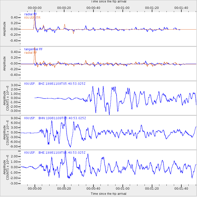
Signal To Noise
| Channel | StoN | STA | LTA |
| KN:USP: :BHN:19981109T05:40:53.025Z | 11.277241 | 8.3092516E-7 | 7.3681605E-8 |
| KN:USP: :BHE:19981109T05:40:53.025Z | 1.988307 | 2.9868258E-7 | 1.5021955E-7 |
| KN:USP: :BHZ:19981109T05:40:53.025Z | 2.9570007 | 3.1731417E-7 | 1.0730947E-7 |
| Arrivals |
| Ps | 6.3 SECOND |
| PpPs | 21 SECOND |
| PsPs/PpSs | 27 SECOND |


