You are here: Home > Network List > G - GEOSCOPE Stations List
> Station WUS Wushi, Xinjiang Uygur, China > Earthquake Result Viewer
WUS Wushi, Xinjiang Uygur, China - Earthquake Result Viewer
| Earthquake location: |
Eastern Honshu, Japan |
| Earthquake latitude/longitude: |
35.8/137.6 |
| Earthquake time(UTC): |
2017/06/24 (175) 22:02:16 GMT |
| Earthquake Depth: |
10 km |
| Earthquake Magnitude: |
5.2 Mww |
| Earthquake Catalog/Contributor: |
NEIC PDE/us |
|
| Network: |
G GEOSCOPE |
| Station: |
WUS Wushi, Xinjiang Uygur, China |
| Lat/Lon: |
41.20 N/79.22 E |
| Elevation: |
1457 m |
|
| Distance: |
45.3 deg |
| Az: |
295.234 deg |
| Baz: |
76.972 deg |
| Ray Param: |
0.0713863 |
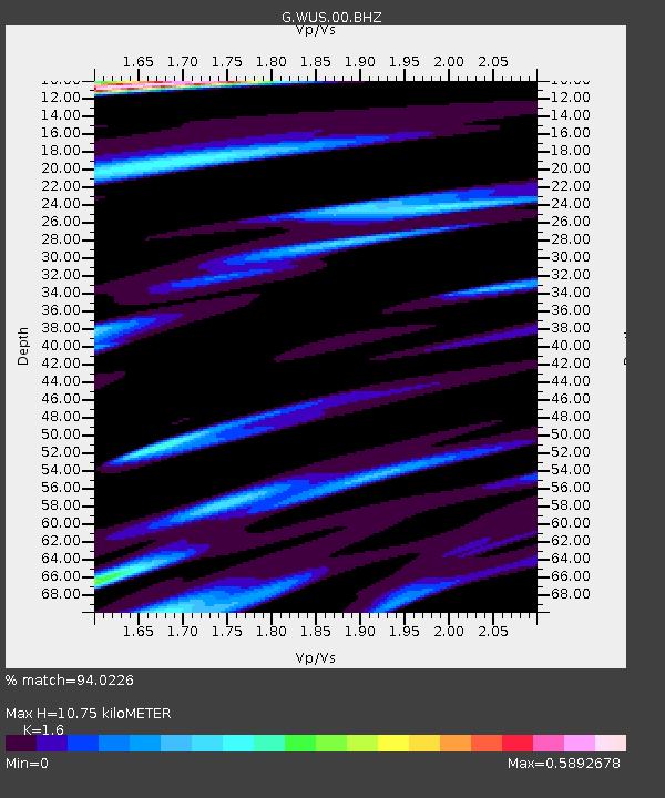
| Estimated Moho Depth: |
10.75 km |
| Estimated Crust Vp/Vs: |
1.60 |
| Assumed Crust Vp: |
6.353 km/s |
| Estimated Crust Vs: |
3.971 km/s |
| Estimated Crust Poisson's Ratio: |
0.18 |
|
| Radial Match: |
94.0226 % |
| Radial Bump: |
334 |
| Transverse Match: |
84.68916 % |
| Transverse Bump: |
400 |
| SOD ConfigId: |
2140511 |
| Insert Time: |
2017-07-08 14:00:14.359 +0000 |
| GWidth: |
2.5 |
| Max Bumps: |
400 |
| Tol: |
0.001 |
|

Signal To Noise
| Channel | StoN | STA | LTA |
| G:WUS:00:BHZ:20170624T22:10:03.55001Z | 18.783718 | 6.1692845E-6 | 3.2843786E-7 |
| G:WUS:00:BHN:20170624T22:10:03.55001Z | 3.6649792 | 5.5251024E-7 | 1.5075399E-7 |
| G:WUS:00:BHE:20170624T22:10:03.55001Z | 9.541966 | 2.6071646E-6 | 2.7323136E-7 |
| Arrivals |
| Ps | 1.1 SECOND |
| PpPs | 4.1 SECOND |
| PsPs/PpSs | 5.2 SECOND |


