You are here: Home > Network List > GS - US Geological Survey Networks Stations List
> Station KAN10 Keim Farm > Earthquake Result Viewer
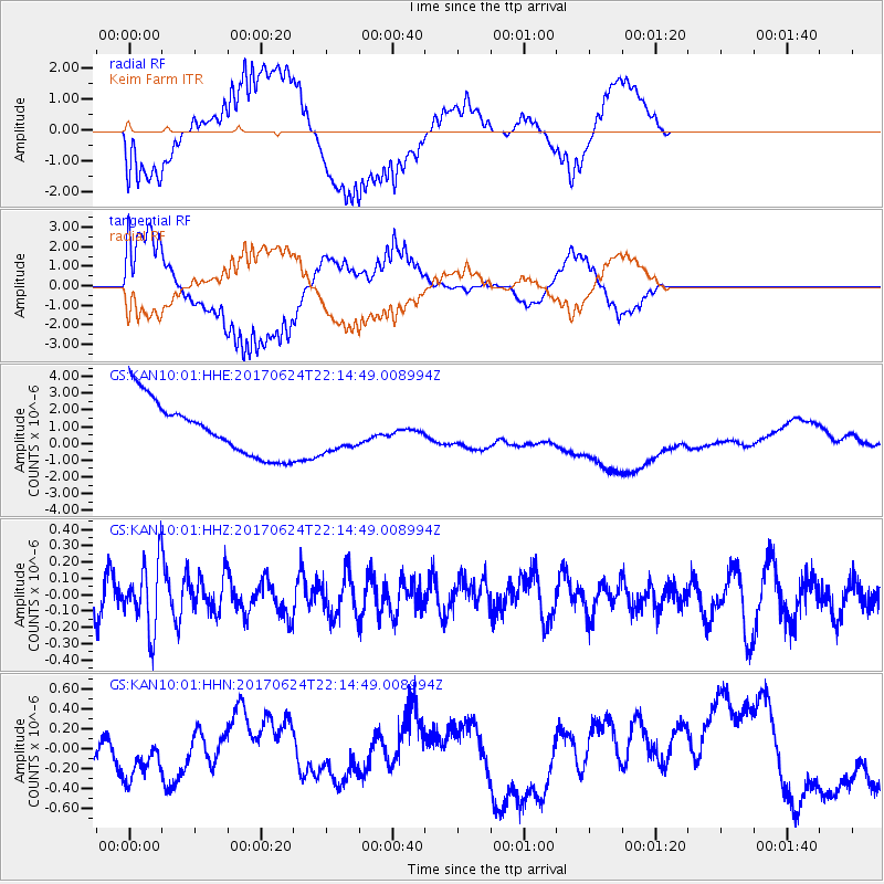
KAN10 Keim Farm - Earthquake Result Viewer
*The percent match for this event was below the threshold and hence no stack was calculated.
| Earthquake location: |
Eastern Honshu, Japan |
| Earthquake latitude/longitude: |
35.8/137.6 |
| Earthquake time(UTC): |
2017/06/24 (175) 22:02:16 GMT |
| Earthquake Depth: |
10 km |
| Earthquake Magnitude: |
5.2 Mww |
| Earthquake Catalog/Contributor: |
NEIC PDE/us |
|
| Network: |
GS US Geological Survey Networks |
| Station: |
KAN10 Keim Farm |
| Lat/Lon: |
37.12 N/98.10 W |
| Elevation: |
417 m |
|
| Distance: |
90.9 deg |
| Az: |
41.332 deg |
| Baz: |
317.813 deg |
| Ray Param: |
$rayparam |
*The percent match for this event was below the threshold and hence was not used in the summary stack. |
|
| Radial Match: |
63.049107 % |
| Radial Bump: |
400 |
| Transverse Match: |
66.18171 % |
| Transverse Bump: |
400 |
| SOD ConfigId: |
2140511 |
| Insert Time: |
2017-07-08 14:00:31.594 +0000 |
| GWidth: |
2.5 |
| Max Bumps: |
400 |
| Tol: |
0.001 |
|
Signal To Noise
| Channel | StoN | STA | LTA |
| GS:KAN10:01:HHZ:20170624T22:14:49.008994Z | 1.5526713 | 2.0086404E-7 | 1.2936674E-7 |
| GS:KAN10:01:HHN:20170624T22:14:49.008994Z | 1.089389 | 3.0961954E-7 | 2.8421394E-7 |
| GS:KAN10:01:HHE:20170624T22:14:49.008994Z | 0.6990085 | 1.1220828E-6 | 1.6052492E-6 |
| Arrivals |
| Ps | |
| PpPs | |
| PsPs/PpSs | |


