You are here: Home > Network List > KN - Kyrgyz Seismic Telemetry Network Stations List
> Station USP KN.USP > Earthquake Result Viewer
USP KN.USP - Earthquake Result Viewer
| Earthquake location: |
Banda Sea |
| Earthquake latitude/longitude: |
-5.5/128.1 |
| Earthquake time(UTC): |
2006/01/27 (027) 16:58:53 GMT |
| Earthquake Depth: |
397 km |
| Earthquake Magnitude: |
7.0 MB, 7.6 MW, 7.5 MW |
| Earthquake Catalog/Contributor: |
WHDF/NEIC |
|
| Network: |
KN Kyrgyz Seismic Telemetry Network |
| Station: |
USP KN.USP |
| Lat/Lon: |
43.27 N/74.50 E |
| Elevation: |
740 m |
|
| Distance: |
68.5 deg |
| Az: |
320.79 deg |
| Baz: |
120.51 deg |
| Ray Param: |
0.054994043 |
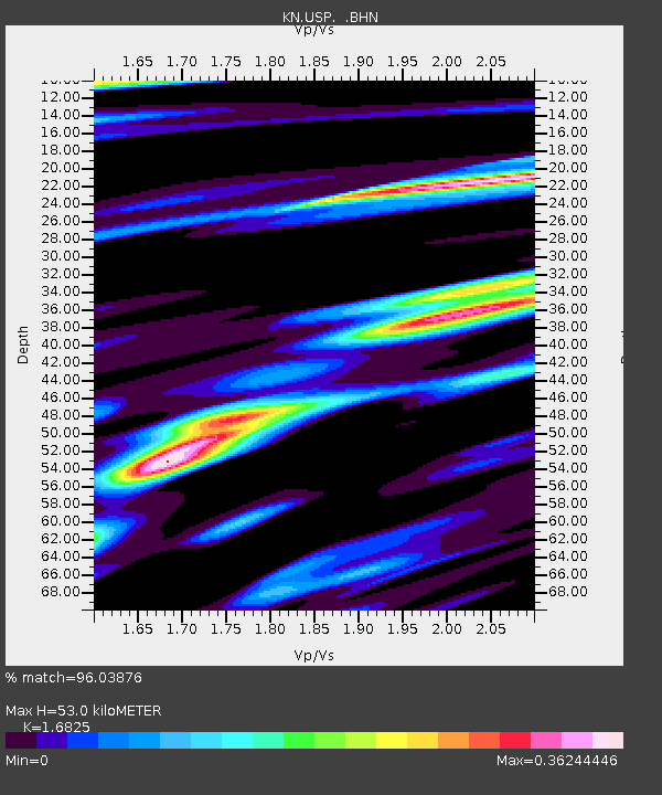
| Estimated Moho Depth: |
53.0 km |
| Estimated Crust Vp/Vs: |
1.68 |
| Assumed Crust Vp: |
6.306 km/s |
| Estimated Crust Vs: |
3.748 km/s |
| Estimated Crust Poisson's Ratio: |
0.23 |
|
| Radial Match: |
96.03876 % |
| Radial Bump: |
279 |
| Transverse Match: |
80.15647 % |
| Transverse Bump: |
400 |
| SOD ConfigId: |
4977 |
| Insert Time: |
2010-03-08 22:19:53.412 +0000 |
| GWidth: |
2.5 |
| Max Bumps: |
400 |
| Tol: |
0.001 |
|
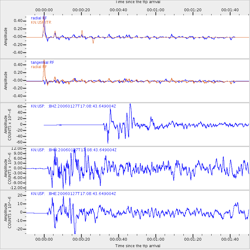
Signal To Noise
| Channel | StoN | STA | LTA |
| KN:USP: :BHN:20060127T17:08:43.649004Z | 44.012386 | 3.0475908E-6 | 6.924394E-8 |
| KN:USP: :BHE:20060127T17:08:43.649004Z | 41.678185 | 5.2471564E-6 | 1.2589696E-7 |
| KN:USP: :BHZ:20060127T17:08:43.649004Z | 67.20517 | 1.5670455E-5 | 2.3317334E-7 |
| Arrivals |
| Ps | 6.0 SECOND |
| PpPs | 22 SECOND |
| PsPs/PpSs | 28 SECOND |


