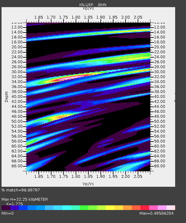
USP KN.USP - Earthquake Result Viewer
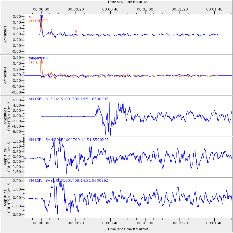
Earthquake location: Kuril Islands
Earthquake latitude/longitude: 46.5/153.2
Earthquake time(UTC): 2006/10/01 (274) 09:06:02 GMT
Earthquake Depth: 19 km
Earthquake Magnitude: 6.1 MB, 6.4 MS, 6.6 MW, 6.5 MW
Earthquake Catalog/Contributor: WHDF/NEIC
Network: KN Kyrgyz Seismic Telemetry Network
Station: USP KN.USP
Lat/Lon: 43.27 N/74.50 E
Elevation: 740 m
Distance: 53.7 deg
Az: 297.249 deg
Baz: 57.267 deg
Ray Param: 0.06590822
Estimated Moho Depth: 32.25 km
Estimated Crust Vp/Vs: 1.77
Assumed Crust Vp: 6.306 km/s
Estimated Crust Vs: 3.553 km/s
Estimated Crust Poisson's Ratio: 0.27
Radial Match: 96.69797 %
Radial Bump: 321
Transverse Match: 83.771805 %
Transverse Bump: 400
SOD ConfigId: 2665
Insert Time: 2010-03-08 22:20:24.249 +0000
GWidth: 2.5
Max Bumps: 400
Tol: 0.001

Signal To Noise

ChannelStoNSTALTA
KN:USP: :BHN:20061001T09:14:51.850029Z4.49244835.611688E-71.249138E-7
KN:USP: :BHE:20061001T09:14:51.850029Z24.5023357.7973124E-73.1822733E-8
KN:USP: :BHZ:20061001T09:14:51.850029Z36.221771.7665052E-64.8769156E-8
Arrivals
Ps4.2 SECOND
PpPs13 SECOND
PsPs/PpSs18 SECOND