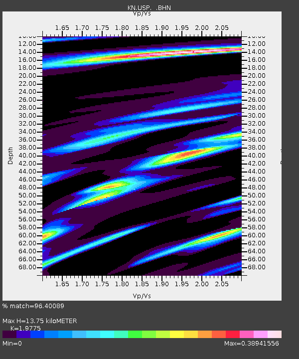
USP KN.USP - Earthquake Result Viewer
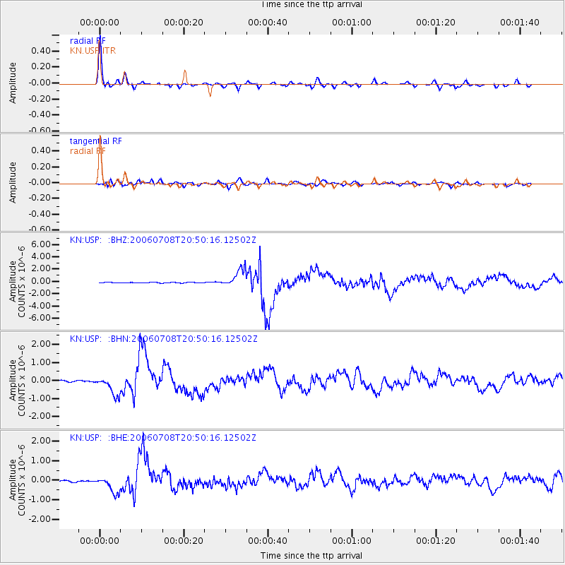
Earthquake location: Andreanof Islands, Aleutian Is.
Earthquake latitude/longitude: 51.2/-179.3
Earthquake time(UTC): 2006/07/08 (189) 20:40:00 GMT
Earthquake Depth: 22 km
Earthquake Magnitude: 6.2 MB, 6.4 MS, 6.6 MW, 6.6 MW
Earthquake Catalog/Contributor: WHDF/NEIC
Network: KN Kyrgyz Seismic Telemetry Network
Station: USP KN.USP
Lat/Lon: 43.27 N/74.50 E
Elevation: 740 m
Distance: 66.2 deg
Az: 309.964 deg
Baz: 41.296 deg
Ray Param: 0.057718225
Estimated Moho Depth: 13.75 km
Estimated Crust Vp/Vs: 1.98
Assumed Crust Vp: 6.306 km/s
Estimated Crust Vs: 3.189 km/s
Estimated Crust Poisson's Ratio: 0.33
Radial Match: 96.40089 %
Radial Bump: 295
Transverse Match: 89.43955 %
Transverse Bump: 400
SOD ConfigId: 2665
Insert Time: 2010-03-08 22:20:44.488 +0000
GWidth: 2.5
Max Bumps: 400
Tol: 0.001

Signal To Noise

ChannelStoNSTALTA
KN:USP: :BHN:20060708T20:50:16.12502Z10.6138595.483343E-75.1662106E-8
KN:USP: :BHE:20060708T20:50:16.12502Z9.6442114.4545996E-74.6189363E-8
KN:USP: :BHZ:20060708T20:50:16.12502Z32.8318821.510356E-64.600272E-8
Arrivals
Ps2.2 SECOND
PpPs6.3 SECOND
PsPs/PpSs8.5 SECOND