You are here: Home > Network List > TA - USArray Transportable Network (new EarthScope stations) Stations List
> Station H31M Peel River, Yukon, CAN > Earthquake Result Viewer
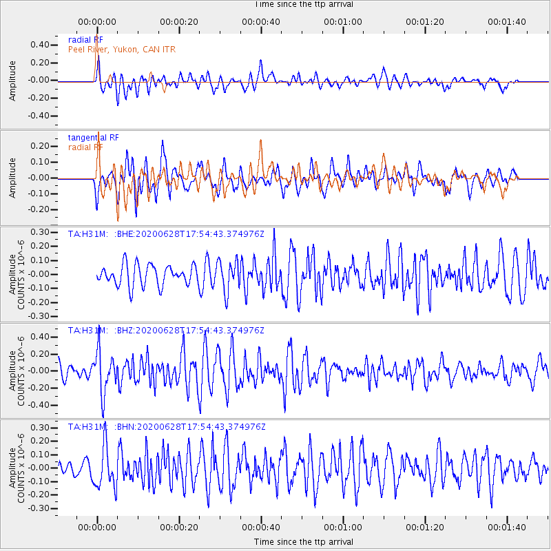
H31M Peel River, Yukon, CAN - Earthquake Result Viewer
*The percent match for this event was below the threshold and hence no stack was calculated.
| Earthquake location: |
Dodecanese Islands, Greece |
| Earthquake latitude/longitude: |
36.7/28.3 |
| Earthquake time(UTC): |
2020/06/28 (180) 17:43:28 GMT |
| Earthquake Depth: |
62 km |
| Earthquake Magnitude: |
5.5 Mww |
| Earthquake Catalog/Contributor: |
NEIC PDE/us |
|
| Network: |
TA USArray Transportable Network (new EarthScope stations) |
| Station: |
H31M Peel River, Yukon, CAN |
| Lat/Lon: |
65.81 N/134.34 W |
| Elevation: |
642 m |
|
| Distance: |
76.9 deg |
| Az: |
352.728 deg |
| Baz: |
14.285 deg |
| Ray Param: |
$rayparam |
*The percent match for this event was below the threshold and hence was not used in the summary stack. |
|
| Radial Match: |
67.26517 % |
| Radial Bump: |
400 |
| Transverse Match: |
60.629925 % |
| Transverse Bump: |
400 |
| SOD ConfigId: |
21709731 |
| Insert Time: |
2020-07-12 18:02:07.649 +0000 |
| GWidth: |
2.5 |
| Max Bumps: |
400 |
| Tol: |
0.001 |
|
Signal To Noise
| Channel | StoN | STA | LTA |
| TA:H31M: :BHZ:20200628T17:54:43.374976Z | 2.979734 | 2.5112885E-7 | 8.427895E-8 |
| TA:H31M: :BHN:20200628T17:54:43.374976Z | 2.170408 | 1.578307E-7 | 7.271937E-8 |
| TA:H31M: :BHE:20200628T17:54:43.374976Z | 1.5115694 | 1.09602546E-7 | 7.250911E-8 |
| Arrivals |
| Ps | |
| PpPs | |
| PsPs/PpSs | |


